Image:African-civilizations-map-pre-colonial.svg
From Wikipedia, the free encyclopedia
African-civilizations-map-pre-colonial.svg (SVG file, nominally 1,390 × 1,295 pixels, file size: 516 KB)
| |
This is a file from the Wikimedia Commons. The description on its description page there is shown below. |
Contents |
Summary
| Description |
Africa History Atlas (precolonial) |
|---|---|
| Source |
self-made |
| Date |
5/01/2007 |
| Author |
Jeff Israel ( ZyMOS) |
| Permission ( Reusing this image) |
see below
|
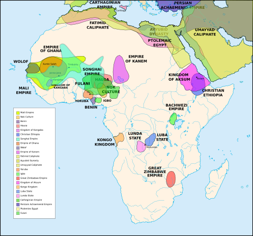
Description
Diachronic map showing pre-colonial cultures of Africa (spanning roughly 500 BCE to 1500 CE)
This map is " an artistic interpretation" using multiple and disparate sources.
Civilizations
These civilizations are shown on the map above
Mali Empire (done):
        [4], [5], [6], [7], [8](1300), 14

Nok Culture(done):
        http://perso.orange.fr/miltiade/Civilisation_de_Nok.htm
        [5]

Fulani empire (aka sokoto empire, Sokoto Calphate, Fulani Empire of Sokoto)  (fulani people are different) (done):
        [2], [10e], [11e]

Benin: (done)
        [7],[14],[16]
Hausa (done)
        [7], [10],[16]

Kingdon of Kangaba (1000AD?) (done)
        [8](1235)

Christian Ethiopia(done)
        [5]

Songhai Empire (done)
        http://commons.wikimedia.org/wiki/Image:Mapa_shonghai.svg
        [3], [4], [5], [6], [7], [8](1300), [16]
        http://www.zum.de/whkmla/histatlas/westafrica/haxmali.html
        http://empathosnationenterprises.com/Consulate/EN-Library/Black-Studies/afempire.html


Empire of Ghana (done):
        [4], [5], [6], [7]


Wolof: (15th century) (done)
        [2],[2c],[14]


Empire of Kanem:(done)
        [15]


Fatimid caliphate(done) 909-1171AD
        [2b],[6b]


Ayyubid dynasty (done) 1171-1250ad
        [1b], [5e], [6e]

Umayyad Caliphate (done) 661-750
        [5b]

Yoruba yorubaland    (done)
        [4b],[2c]

Igbo    (done)
        [4b],


Great Zimbabwe (done):
        [5], [7]


Kingdom of aksum (Axum?) 1bc-7ad  (done)
        [12b],[14b],[15b]

Kongo Kingdom     (done)
        [1c], [2c],[15]


Luba State (done) 15-19th century
        [2c],[4c]

Lunda State (done) 15-19th century
        [2c],[4c],


Carthaginian Empire(done) (220BCE) Carthage
        [2c], [3c]


Persian Achaemenid Empire (done)
        [2e],3e].4e],[


THE PTOLEMIES (done)
        [8e], [9e]
Civilizations to be added
These civilizations have not been added because the borders have not yet been confirmed, or there is some uncertainty if they are a true civilization. Please add them to the map if you are able to define the borders of these civilizations.
Akan States (generric term for states with the akan people):
        [7],

Kano (independent city-state) (1000-1903):
        [14]

Kaarta (kingdom of Kaarta) (1753-1854):
        [14]

Macina (Macina Empire) (aka Dina of Massina, Sise Jihad state, and Caliphate of Hamdullahi) (1818-1862):
        [14]

Segou (city 1620):
        [14]

Kingdom of Fouta Djallon (Futa Djalon or Kingdom of Fuuta Jallon):
        [14]

Hausa Bakwai (initial stage Hausa):
        [11e]

Wassoulou Empire (Ouassoulou) (1878 - 1898) :
        [14]

Kénédougou Kingdom (Kenedougou) (1650-1898):
        [14]

Ouagadougou (15th century CITY):
        [14]

Ashanti Kingdom:
        [14]

Dahorney:
        [14]

Gando (16th century town):
        [14]

kingdom of Takrur (c. 800 - c. 1285) :
        [8](1300), [13]

Oyo empire (1400-1796)


Bornu Empire (1396-1893):
        [2],[15], [10e]

Bornu-Kanem (a portion of kanem history where they merged):
        [7],[2c]

Wodaabe (a people of africa):
        [10]

Mamluk Sultanate of Egypt (1174-1820):
        [2],[12],

Kush?Kushite kingdom?:

Axum (see kingdom of aksum):

Buganda kingdom (changed to Unganda, but remained as Buganda people):

Lozi???:

Malawi Empire (late 15th centure and converted to Malawi Contry):

Kilwa (Kilwa Kisiwani, 9th century,  is an Islamic community is present day tanzania):
        [2c]


Abyssinia???:
        [2], [7]

Soha????:
        [2],

Nubia(area in egypt, not kingdom):
        [7],

Kingdom of Kerma(2500BC-1520BC):


=North Central=

Sahariano??:
        [1],

Maban????????:
        [1],

Fur(a people:
        [1],

Sudanes Central (language Central Sudanic):
        [1],

=East Central=

Sudanes Meridional???:
        [1],

Berta(language>:
        [1],

Kunama(a people):
        [1],

Komuz???instument:
        [1],

Aksumite Civilization
        [7b], [9b(maybey], [13b(aksum)]

Kingdom of Sheva???
        [8b]

Egypt
        [10b]

JolofEmpire (also called Dyolof or Wolof), wolof should be changed to this:
        [11b]


Meroe(city, capital of Kushitic Kingdom))
        [12b]

Bantu(ethnic group)
        [12b]

Khoisan(ethnic group)
        [12b]


Almoravid Empire
        [5c], [1f]


Monomotapa
        [2c],

Lozi
        [2c]

Zulu Kingdom
        [2c]

Merina
        [2c]

Malawi
        [2c]

Rawanda
        [2c]

Buganada
        [2c]

Kazembe
        [4c]


Punt (3000BC-1000BC):
        location lost in time

D'mt (800BC-100BC):


Gudit (1000AD):

Zagwe Dynasty (1000-1268AD):
        [6e]

Solomonic dynasty (1270-1974AD)

Himyar:
        [1d]


Qataban:
        [1d]

Saba:
        [1d]

Hadhramaut:
        [1d]


Thutmoses 1
        [1e]

Ramesses II
        [1e]

Assurbanipal, empire of
        [7e]
Editing this page and map
Suggestions before editing this map: Be sure to confirm it with multiple sources, and that it would be considered a true civilization. Also if you add to the map please name the layers and objects to keep it organized. Allot of the civilizations on this page do not have the times they existed. If this could be added it would be very beneficial. Then the map could be easily split into eras.
References
The original map came from
- some of the features where removed to simplify it.
- "The Harper Atlas of World History", 1987, William Collins Son & Co Ltd, New York, pg131
- is [6b]
- [1b] http://www.metmuseum.org/toah/hd/ayyu/hd_ayyu.htm
- [2b] http://www.metmuseum.org/toah/hd/fati/hd_fati.htm
- [3b] http://www.metmuseum.org/toah/hd/pave/hd_pave.htm
- [4b] http://www.metmuseum.org/toah/hd/pave/hd_pave.htm
- [5b] http://www.metmuseum.org/toah/hd/umay/hd_umay.htm
- [6b] http://countryturkmenistan.tripod.com/index.blog?from=20050708
- [7b] http://en.wikipedia.org/wiki/Image:LocationAksumiteEmpire.png
- [8b] http://www.imninalu.net/tribes2.htm
- [9b] http://www.freewebs.com/eritrea2001/infocenter.htm
- [10b] http://www.iziko.org.za/sh/resources/egypt/history_new_kingdom.htm
- [11b] http://www.geocities.com/jbenhill/timeline.html
- [12b] http://p083.ezboard.com/Not-all-of-Africans-belong-to-Bantu-or-Negroid-race/fbalkansfrm57.showMessage?topicID=56.topic
- [13b] http://www.homestead.com/wysinger/aksum.html
- [14b] http://news.asmarino.com/TomasMebrahtu/Images/Map_.jpg
- [15b] http://en.wikipedia.org/wiki/Image:GDRT230.jpg
- [16b] http://www.bible.ca/islam/islam-aksum-map-0-700ad.jpg
- [1c] http://www.metmuseum.org/toah/hd/acko/acko_d1map.htm
- [2c] http://exploringafrica.matrix.msu.edu/teachers/curriculum/m7b/activity1.php
- [3c] http://www.livius.org/cao-caz/carthage/carthage.html
- [4c] http://concise.britannica.com/ebc/article-9370655/Luba-Lunda-states
- [5c] http://www.allempires.com/forum/forum_posts.asp?TID=6586&PN=1
- [1e] http://www.iziko.org.za/sh/resources/egypt/history_new_kingdom.htm
- [2e] http://commons.wikimedia.org/wiki/Image:Achaemenid_Empire.jpg
- [3e] http://commons.wikimedia.org/wiki/Image:Carte_empire_ach%C3%A9m%C3%A9nide.png
- [4e] http://commons.wikimedia.org/wiki/Image:Persian_empire_490bc.gif
- [5e] http://commons.wikimedia.org/wiki/Image:Ayyubids1189.png
- [6e] http://commons.wikimedia.org/wiki/Image:Ayyubid.png
- [7e] http://www.fortunecity.com/tatooine/acegarp/898/10000bc601.htm
- [8e] http://www.transanatolie.com/English/Turkey/Anatolia/Hellens/hellens.htm
- [9e] http://www.unc.edu/awmc/downloads/aegyptusPtolSml.jpg
- [10e] http://www.amanaonline.com/Sokoto/table_of_content.htm
- [11e] http://www.britannica.com/ebi/art-3910?articleTypeId=1
- [1f] http://en.wikipedia.org/wiki/Image:Almoravid-empire-en.svg
- [1x] http://commons.wikimedia.org/wiki/Image:Africa_15.PNG
- [2x] http://commons.wikimedia.org/wiki/Image:Africa_13.PNG
Licensing
|

File history
Click on a date/time to view the file as it appeared at that time.
| Date/Time | Dimensions | User | Comment | |
|---|---|---|---|---|
| current | 19:43, 31 August 2007 | 1,390×1,295 (516 KB) | ZyMOS | ({{Information |Description=Africa History Atlas (precolonial) |Source=self-made |Date=5/01/2007 |Author= ZyMOS }} ) |