Image:TC Rosita.jpg
From Wikipedia, the free encyclopedia
Size of this preview: 572 × 480 pixels
Full resolution (1,080 × 906 pixels, file size: 331 KB, MIME type: image/jpeg)
| |
This is a file from the Wikimedia Commons. The description on its description page there is shown below. |
Summary
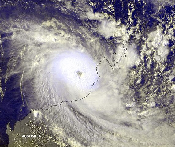
| Description |
Tropical Cyclone 27S, Rosita, was located near 17.6S 120.6E moving in an east-southeast direction at 6 knots toward the Australian coast. Maximum sustained winds were estimated at 100 knots, gusts to 110 knots. |
|||
|---|---|---|---|---|
| Source |
http://www.osei.noaa.gov/Events/Tropical/IndOcean/2000/TRC27S110_GM.jpg |
|||
| Date |
2000-04-19 |
|||
| Author |
NOAA / Operational Significant Event Imagery |
|||
| Permission ( Reusing this image) |
|


File history
Click on a date/time to view the file as it appeared at that time.
| Date/Time | Dimensions | User | Comment | |
|---|---|---|---|---|
| current | 19:40, 8 October 2006 | 1,080×906 (331 KB) | Good kitty | (cropped) |
| 12:40, 8 July 2006 | 800×594 (163 KB) | Hurricanehink | ({{Information |Description=Tropical Cyclone Rosita near peak intensity |Source=http://www.lancewood.net/redbill/images/Chapter12/tn/1206-Rosita.med.jpg |Date=2006-07-08 |Author=NOAA |Permission={{PD-USGov-NOAA}} |other_versions= }} [[Category:Tropical cy) |
File links
The following pages on Schools Wikipedia link to this image (list may be incomplete):