Image:Bilis TRMM.jpg
From Wikipedia, the free encyclopedia
Size of this preview: 480 × 480 pixels
Full resolution (1,024 × 1,024 pixels, file size: 509 KB, MIME type: image/jpeg)
| |
This is a file from the Wikimedia Commons. The description on its description page there is shown below. |
Summary
| Description |
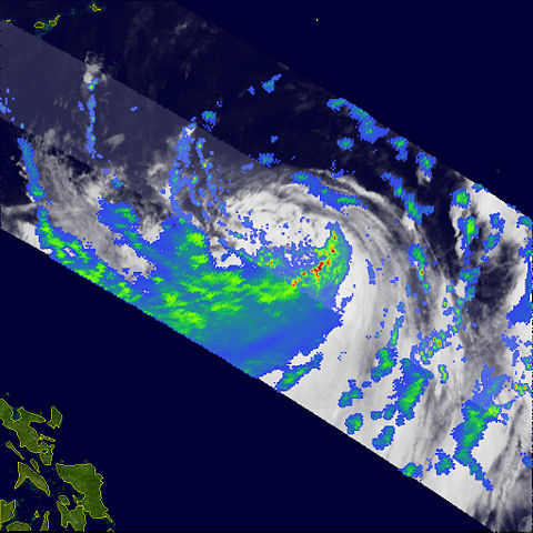
Although the centre of Tropical Storm Bilis (known as Florita in the Philippines) passed well to the north of Luzon, it has been blamed for at least 14 fatalities on the island as a result of flash floods, mudslides, and wind damage. The storm formed as a tropical depression on July 8, 2006, south of Guam. The depression intensified into a tropical storm the following day as it crossed the central Philippine Sea and assumed a more northwesterly track. The Tropical Rainfall Measuring Mission (TRMM) satellite observed Bilis on July 10, 2006, at 21:37 UTC, as the storm was passing through the Philippine Sea well northeast of the islands. The image shows the horizontal distribution of rain intensity within the storm as seen from the TRMM satellite. Rain rates in the centre swath are from the TRMM Precipitation Radar, while rain rates in the outer swath are from the TRMM Microwave Imager. The rain rates are overlaid on infrared data from the TRMM Visible Infrared Scanner. In this image, Bilis appears as a highly asymmetrical storm, with the vast majority of the rain occurring south of the center in a rather large band (broad green and blue area). The actual center itself was rather poorly defined. Near the time of this image, the Joint Typhoon Warning Center estimated the maximum sustained winds to be 92 kilometers per hour (58 miles per hour), the equivalent of a moderate tropical storm. As Bilis continued to track to the northwest, this band of rain and its associated circulation came ashore over Luzon in the northern Philippines. Although the storm’s centre remained well off the coast, the interaction of heavy rain and mountainous terrain led to flash flooding and mudslides. The Tropical Rainfall Measuring Mission satellite (known as TRMM) was placed into service in November of 1997. From its low-earth orbit, TRMM has been providing valuable images and information on storm systems around the Tropics using a combination of passive microwave and active radar sensors, including the first precipitation radar in space. TRMM is a joint mission between NASA and the Japanese space agency, JAXA. |
|||||
|---|---|---|---|---|---|---|
| Source |
http://earthobservatory.nasa.gov/NaturalHazards/natural_hazards_v2.php3?img_id=13711 |
|||||
| Date |
2006-07-10 |
|||||
| Author |
Images produced by Hal Pierce (SSAI/NASA GSFC) and caption by Steve Lang (SSAI/NASA GSFC). |
|||||
| Permission ( Reusing this image) |
|


File history
Click on a date/time to view the file as it appeared at that time.
| Date/Time | Dimensions | User | Comment | |
|---|---|---|---|---|
| current | 22:29, 12 September 2006 | 1,024×1,024 (509 KB) | Coredesat | (TRMM image of Tropical Storm Bilis (2006-05W) from the [http://visibleearth.nasa.gov NASA Visible Earth site]. {{PD-USGov-NASA}} ) |
File links
Metadata
This file contains additional information, probably added from the digital camera or scanner used to create or digitize it. If the file has been modified from its original state, some details may not fully reflect the modified file.
| Width | 1024 |
|---|---|
| Height | 1024 |
| Compression scheme | Uncompressed |
| Pixel composition | RGB |
| Orientation | Normal |
| Number of components | 3 |
| Horizontal resolution | 72 dpi |
| Vertical resolution | 72 dpi |
| Data arrangement | chunky format |
| Software used | Adobe Photoshop CS2 Macintosh |
| File change date and time | 16:04, 14 July 2006 |
| Colour space | 65535 |