Image:Abadan.png
From Wikipedia, the free encyclopedia
No higher resolution available.
Abadan.png (157 × 222 pixels, file size: 13 KB, MIME type: image/png)
| |
This is a file from the Wikimedia Commons. The description on its description page there is shown below. |
Summary
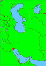
Español: Situación geográfica de Abadán
from en.wiki:
This map was generated using GMT software (The Generic Mapping Tools). Converstion to png format was done using ImageMagick [sic] image processing tools.
Author: K1
Licensing
 |
Permission is granted to copy, distribute and/or modify this document under the terms of the GNU Free Documentation License, Version 1.2 or any later version published by the Free Software Foundation; with no Invariant Sections, no Front-Cover Texts, and no Back-Cover Texts. Subject to disclaimers. Asturianu | Български | Català | Deutsch | English | Español | Français | Gaeilge | Italiano | Polski | Português | +/- |
File history
Click on a date/time to view the file as it appeared at that time.
| Date/Time | Dimensions | User | Comment | |
|---|---|---|---|---|
| current | 08:42, 4 September 2005 | 157×222 (13 KB) | Square87 |
File links
The following pages on Schools Wikipedia link to this image (list may be incomplete):