Image:Midway Atoll.jpg
From Wikipedia, the free encyclopedia
Size of this preview: 510 × 480 pixels
Full resolution (658 × 619 pixels, file size: 110 KB, MIME type: image/jpeg)
| |
This is a file from the Wikimedia Commons. The description on its description page there is shown below. |
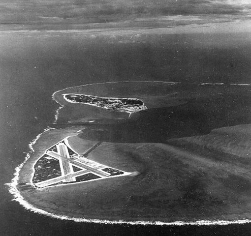
Caption: Midway Atoll. Aerial photograph, looking just south of west across the southern side of the atoll, 24 November 1941. Eastern Island, then the site of Midway's airfield, is in the foreground. Sand Island, location of most other base facilities, is across the entrance channel.
Source: http://www.history.navy.mil/photos/images/g450000/g451086.jpg
Licensing
 |
This image is a work of a sailor or employee of the U.S. Navy, taken or made during the course of the person's official duties. As a work of the U.S. federal government, the image is in the public domain. |
 |
File history
Click on a date/time to view the file as it appeared at that time.
| Date/Time | Dimensions | User | Comment | |
|---|---|---|---|---|
| current | 20:18, 8 July 2006 | 658×619 (110 KB) | Sebmol | (Caption: Midway Atoll. Aerial photograph, looking just south of west across the southern side of the atoll, 24 November 1941. Eastern Island, then the site of Midway's airfield, is in the foreground. Sand Island, location of most other base facilitie) |
File links
The following pages on Schools Wikipedia link to this image (list may be incomplete):