Image:Western Europe in the Time of Charles V (1525).jpg
From Wikipedia, the free encyclopedia
Size of this preview: 369 × 479 pixels
Full resolution (893 × 1,160 pixels, file size: 226 KB, MIME type: image/jpeg)
| |
This is a file from the Wikimedia Commons. The description on its description page there is shown below. |
Summary
| Description |
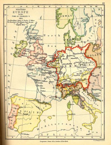
Map of Western Europe in the Time of Charles V (1525) |
|---|---|
| Source |
A School Atlas of English History |
| Date |
1892 |
| Author |
Samuel Rawson Gardiner (1829–1902) |
| Permission ( Reusing this image) |
Public domain as a work published in 1892, and as a work whose author has been dead for more than 70 years.
|
Licensing
 |
This media file is in the public domain in the United States. This applies to U.S. works where the copyright has expired, often because its first publication occurred prior to January 1, 1923. See this page for further explanation. |
|
|
Deutsch | English | Español | Français | Gaeilge | Galego | Italiano | Nederlands | 中文(简体) | +/- |
||
|
|
This image might not be in the public domain outside of the United States (this especially applies in Canada, China (not Hong Kong, Macao, or Taiwan Area), Germany, Mexico, and Switzerland). The creator and year of publication are essential information and must be provided. See Wikipedia:Public domain and Wikipedia:Copyrights for more details. |
|
|
This image (or other media file) is in the public domain because its copyright has expired. This applies to the United States, Canada, the European Union and those countries with a copyright term of life of the author plus 70 years. العربية | Asturianu | Български | Català | Česky | Dansk | Deutsch | English | Ελληνικά | Esperanto | Español | Euskara | فارسی | Français | Gaeilge | Galego | עברית | हिन्दी | Bahasa Indonesia | Italiano | 日本語 | 한국어 | Kurdî / كوردی | Lietuvių | Magyar | Nederlands | Norsk (nynorsk) | Македонски | Bahasa Melayu | Polski | Português | Română | Русский | Slovenčina | Slovenščina | Shqip | Suomi | Sámegiella | Türkçe | 中文(简体) | 中文(繁體) | 粵語 | +/- |
File history
Click on a date/time to view the file as it appeared at that time.
| Date/Time | Dimensions | User | Comment | |
|---|---|---|---|---|
| current | 16:37, 5 June 2006 | 893×1,160 (226 KB) | Kirill Lokshin | ({{Information |Description= Map of Western Europe in the Time of Charles V (1525) |Source= [http://www.livgenmi.com/gardiner22.htm A School Atlas of English History] |Date= 1892 |Author= Samuel Rawson Gardiner |Permission= Public domain as a work [http://) |