Image:SantaCruzChart2.jpg
From Wikipedia, the free encyclopedia
No higher resolution available.
SantaCruzChart2.jpg (475 × 418 pixels, file size: 42 KB, MIME type: image/jpeg)
| |
This is a file from the Wikimedia Commons. The description on its description page there is shown below. |
Summary
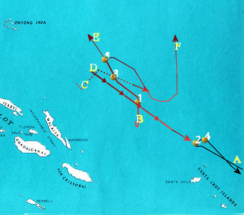
Chart of the Battle of the Santa Cruz Islands, October 26, 1942, showing approximate paths of participating forces.
Tracks:
- A- U.S. carrier task forces: Hornet and Enterprise (solid black line)
- B- Japanese "Main" body under Chuichi Nagumo with carriers Zuiho, Shokaku, and Zuikaku (solid red line)
- C- Japanese carrier Junyo under Rear Admiral Kakuji Kakuta (dotted red line)
- D- Japanese battleship and cruiser "Advanced" and "Vanguard" forces under Nobutake Kondo and Hiroaki Abe (arrowed red line)
- E- Zuiho and Shokaku withdraw from battle area
- F- Zuikaku and Junyo join to launch afternoon strikes on U.S. carrier forces
Numbered yellow dots:
- 1- 08:30-Zuiho hit
- 2- 10:15-Hornet hit and crippled
- 3- 10:20-Shokaku hit
- 4- 11:15-Enterprise hit
- 5- 12:30-Zuiho and Shokaku retire from the battle area.
Background taken from (which is a U.S. government public domain document) and modified by myself, cla68, on July 5, 2006 to include warship forces battle tracks. Released under the GFDL.
Licensing
|

File history
Click on a date/time to view the file as it appeared at that time.
| Date/Time | Dimensions | User | Comment | |
|---|---|---|---|---|
| current | 00:34, 6 July 2006 | 475×418 (42 KB) | Cla68 | (Chart of the Battle of the Santa Cruz Islands, October 26, 1942, showing approximate paths of participating forces. Key: * A- U.S. carrier task forces: ''Hornet'' and ''Enterprise'' * B- Japanese "Main" body under Chuichi Nagumo with carriers ''Zuiho'') |