Image:Locations in north Britain in the early tenth century.png
From Wikipedia, the free encyclopedia
Size of this preview: 308 × 480 pixels
Full resolution (385 × 600 pixels, file size: 209 KB, MIME type: image/png)
| |
This is a file from the Wikimedia Commons. The description on its description page there is shown below. |
| Description |
Work derived from Image:Scotland Land Use by height.png. Licensing per that image. Created by user:SFC9394. Licensed CCSA2.5 and GFDL per original work. |
|---|---|
| Source |
From Image:Scotland Land Use by height.png |
| Date |
2006-04-16, this modified version 2007-05-12 |
| Author |
SFC9394 |
| Permission ( Reusing this image) |
See below
|
Licensing
| |
This file is licensed under the Creative Commons Attribution ShareAlike 2.5 License. In short: you are free to share and make derivative works of the file under the conditions that you appropriately attribute it, and that you distribute it only under a license identical to this one. Official license |
|

Original Description
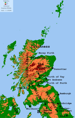
Map of Scotland showing three height graduations (<200m, 200-600m, 600m+) for use in describing land usage, as requested by Angus McLellan
Height data derived from NASA SRTM and GTOPO30, both PD.
Map key
The map shows some locations mentioned in late C9th/early C10th sources.
The lines marked A and B are:
- A: the approximate southern boundary of the en:Kingdom of Alba, c. 900–950
- B: the approximate southern boundary of the en:Kingdom of Strathclyde, at about 927.
All locations are approximate.
File history
Click on a date/time to view the file as it appeared at that time.
| Date/Time | Dimensions | User | Comment | |
|---|---|---|---|---|
| current | 13:35, 9 December 2007 | 385×600 (209 KB) | Angusmclellan | ({{Information |Description= |Source= |Date= |Author= |Permission= |other_versions= }} ) |
| 20:38, 6 December 2007 | 385×600 (204 KB) | Angusmclellan | ||
| 23:21, 5 December 2007 | 308×480 (139 KB) | Angusmclellan | ({{Information |Description=Work derived from Image:Scotland Land Use by height.png. Licensing per that image. Created by user:SFC9394. Licensed CCSA2.5 and GFDL per original work. |Source=From Image:Scotland Land Use by height.png |Date=200) |