Image:Ph map negros oriental.png
From Wikipedia, the free encyclopedia
Size of this preview: 443 × 480 pixels
Full resolution (600 × 650 pixels, file size: 37 KB, MIME type: image/png)
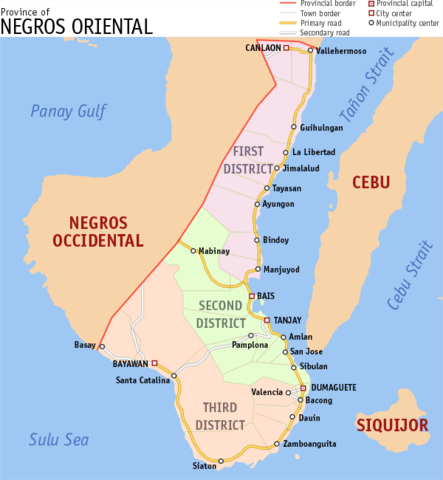
Map of Negros Oriental. Created by TheCoffee. Released under the GNU FDL.
| |
I, the creator of this work, hereby grant the permission to copy, distribute and/or modify this document under the terms of the GNU Free Documentation License, Version 1.2 or any later version published by the Free Software Foundation; with no Invariant Sections, no Front-Cover Texts, and no Back-Cover Texts. Subject to disclaimers. |
File history
Click on a date/time to view the file as it appeared at that time.
| Date/Time | Dimensions | User | Comment | |
|---|---|---|---|---|
| current | 07:00, 11 February 2006 | 600×650 (37 KB) | TheCoffee ( Talk | contribs) | (Map of Negros Oriental. Created by TheCoffee. Released under the GNU FDL. {{GDFL-self}}) |
See the setup instructions for more information.
File links
The following pages on Schools Wikipedia link to this image (list may be incomplete):
Categories: Self-published work