Image:Europe20000ya.png
From Wikipedia, the free encyclopedia
Size of this preview: 640 × 426 pixels
Full resolution (1,900 × 1,264 pixels, file size: 98 KB, MIME type: image/png)
| |
This is a file from the Wikimedia Commons. The description on its description page there is shown below. |
Summary
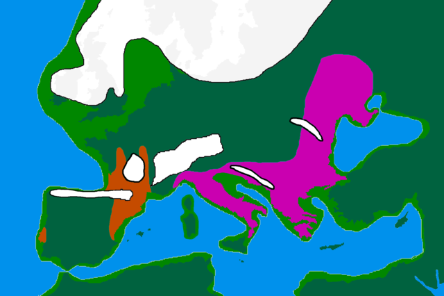
| Description |
map of Europe 20,000 years ago. |
|---|---|
| Source |
made by me from Image:BlankMap-Europe-v3.png, which is GFDL v1.2, outline of ancient coast and extent of ice added by me from information from "After the Ice: A Global History" by Steve Mithen. Information about human refugia from "Origins of the British" by Stephen Oppenheimer and "Out of Eden by Stephen Oppenheimer. These were sketched in by me from information supplied by these books. Coloured areas are the furthest extent of the cultures between 15 kya and 20 kya. ██ Solutrean and Proto Solutrean Cultures ██ Epi Gravettian Culture |
| Date |
25 Februare 2007 |
| Author |
User:Wobble |
| Permission ( Reusing this image) |
GFDL
|
Licensing
 |
Permission is granted to copy, distribute and/or modify this document under the terms of the GNU Free Documentation license, Version 1.2 or any later version published by the Free Software Foundation; with no Invariant Sections, no Front-Cover Texts, and no Back-Cover Texts. A copy of the license is included in the section entitled " GNU Free Documentation license". Aragonés | العربية | Asturianu | Беларуская (тарашкевіца) | Български | বাংলা | ইমার ঠার/বিষ্ণুপ্রিয়া মণিপুরী | Brezhoneg | Bosanski | Català | Cebuano | Česky | Dansk | Deutsch | Ελληνικά | English | Esperanto | Español | Eesti | Euskara | فارسی | Suomi | Français | Gaeilge | Galego | עברית | Hrvatski | Magyar | Bahasa Indonesia | Ido | Íslenska | Italiano | 日本語 | ქართული | ភាសាខ្មែរ | 한국어 | Kurdî / كوردی | Latina | Lëtzebuergesch | Lietuvių | Bahasa Melayu | Nnapulitano | Nederlands | Norsk (nynorsk) | Norsk (bokmål) | Occitan | Polski | Português | Română | Русский | Slovenčina | Slovenščina | Shqip | Српски / Srpski | Svenska | తెలుగు | ไทย | Tagalog | Türkçe | Українська | اردو | Tiếng Việt | Volapük | Yorùbá | 中文(简体) | 中文(繁體) | +/- |
File history
Click on a date/time to view the file as it appeared at that time.
| Date/Time | Dimensions | User | Comment | |
|---|---|---|---|---|
| current | 16:00, 12 April 2007 | 1,900×1,264 (98 KB) | Wobble | (Reverted to earlier revision) |
| 15:59, 12 April 2007 | 1,000×665 (106 KB) | Wobble | (Reverted to earlier revision) | |
| 15:50, 12 April 2007 | 1,900×1,264 (98 KB) | Wobble | (better version, shows refugia better, from Oppenheimer, Out of Eden) | |
| 08:13, 28 March 2007 | 1,000×665 (106 KB) | Dbachmann | (shrunk; accounting for Black Sea flood.) | |
| 18:59, 25 February 2007 | 1,900×1,264 (129 KB) | Wobble | ({{Information |Description=map of Europe 20,000 years ago. |Source=made from Image:BlankMap-Europe-v3.png, which is GFDL v1.2 by me, outline of coast and extent of ice added by me from information from "After the Ice: A GLoba History" by Steve Mithen.) |