From Wikipedia, the free encyclopedia
 No higher resolution available.The_Catlins.jpg
 (392 × 309 pixels, file size: 26 KB, MIME type: image/jpeg)
 |
This is a file from the Wikimedia Commons. The description on its description page there is shown below.Commons is a freely licensed media file repository. You can help.
|
Summary
| Description |
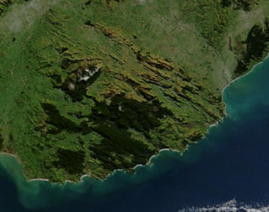
This satellite image shows the Catlins, a region in the southeast of New Zealand's South Island, after a severe blizzard hit the island in July 2003. The dark green areas are forested, while most of the light green and yellow areas are farmed. White patches are covered in snow. |
| Source |
NASA's Earth Observatory |
| Date |
2002-10-23 |
| Author |
Jacques Descloitres, MODIS Rapid Response Team at NASA GSFC |
Permission
( Reusing this image) |
|
|
This file is in the public domain because it was created by NASA. NASA copyright policy states that "NASA material is not protected by copyright unless noted". ( NASA copyright policy page or JPL Image Use Policy).
Deutsch | English | Español | Français | Galego | Nederlands | Português | Русский | 中文(简体) | 中文(繁體) | +/- |
|
|
|
Warnings:
- Use of NASA logos, insignia and emblems are restricted per US law 14 CFR 1221.
- The NASA website hosts a large number of images from the Soviet/ Russian space agency, and other non-American space agencies. These are not necessarily in the public domain.
- Materials from the Hubble Space Telescope may be copyrighted if they do not explicitly come from the STScI.
- All materials created by the SOHO probe are copyrighted and require permission for commercial non-educational use.
- Images featured on the Astronomy Picture of the Day (APOD) web site may be copyrighted.
|
|
| Other versions |
Full view of the South Island at Image:South Island blizzard 2003.jpg |
This satellite image shows the Catlins, a region in the southeast of New Zealand's South Island.
Image courtesy Jacques Descloitres, MODIS Rapid Response Team at NASA GSFC.
SOURCE: http://earthobservatory.nasa.gov/NaturalHazards/shownh.php3?img_id=10797
”The purpose of NASA's Earth Observatory is to provide a freely-accessible publication on the Internet where the public can obtain new satellite imagery and scientific information about our home planet. The focus is on Earth's climate and environmental change. In particular, we hope our site is useful to public media and educators. Any and all materials published on the Earth Observatory are freely available for re-publication or re-use, except where copyright is indicated. We ask that NASA's Earth Observatory be given credit for its original materials.”
File history
Click on a date/time to view the file as it appeared at that time.
|
|
Date/Time |
Dimensions |
User |
Comment |
| current |
13:51, 19 May 2006 |
392×309 (26 KB) |
Avenue |
|
|
|
02:33, 18 May 2006 |
461×332 (23 KB) |
Avenue |
|
File links
The following pages on Schools Wikipedia link to this image (list may be incomplete):


