Image:World Map 1689.JPG

From Wikipedia, the free encyclopedia
Wikimedia Commons logo This is a file from the Wikimedia Commons. The description on its description page there is shown below.
Commons is a freely licensed media file repository. You can help.
POTY
Featured picture
This file was a candidate on Picture of the Year 2006.
This is a featured picture on Wikimedia Commons: it is considered one of our finest images.
This is a featured picture on English Wikipedia and is considered one of the finest images.
This is a featured picture on Turkish Wikipedia and is considered one of the finest images.
If you have an image of similar quality that can be published under a suitable copyright license, be sure to upload it, tag it, and nominate it.
Wikimedia Commons
Picture of the day This image was selected as a picture of the day for February 07, 2007. It was captioned as followed:
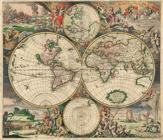
English: An old world map produced in Amsterdam 1689.

Česky: Mapa světa z roku 1689 uložená v Amsterodamu
Deutsch: Eine 1689 in Amsterdam hergestellte Weltkarte.
English: An old world map produced in Amsterdam 1689.
Esperanto: Antikva platglobo desegnita dum 1689 en Amsterdamo, Nederlando
Español: Un antiguo planisferio, hecho en el año 1689 en Ámsterdam, Países Bajos.
Suomi: Hollantilainen maailmankartta vuodelta 1689
Français : Un ancien planisphère, réalisé en 1689 à Amsterdam.
עברית: מפת עולם משנת 1689 מאמסטרדם
Magyar: Van Schagen 1689-ben, Amszterdamban készített világtérképe
Italiano: Planisfero prodotto ad Amsterdam nel 1689.
日本語: アムステルダムで1689年に制作された 世界地図
Polski: Mapa świata wyprodukowana w Amsterdamie w roku 1689.
Português: Velho mapa-múndi, produzido em Amsterdã, Países Baixos, em 1689.
Română: O veche hartă a lumii, realizată la Amsterdam în 1689.
Русский: Планисфера, созданная в 1689 г. в Амстердаме.
Српски / Srpski: Стара карта света направљена у Амстердаму 1689.
Svenska: En gammal världskarta tillverkad i Amsterdam 1689.
Türkçe: 1689 yılında Amsterdam'da yapılan eski dünya haritası.
‪中文(简体)‬: 1689年在 荷兰 阿姆斯特丹绘制的一幅 世界地图
‪中文(繁體)‬: 1689年在 荷蘭 阿姆斯特丹繪製的一幅 世界地圖

Summary

Description
English: World map - Produced in Amsterdam
First edition : 1689. Original size : 48.3 x 56.0 cm. Produced using copper engraving. Extremely rare set of maps, only known in one other example in the Amsterdam University. No copies in American libraries. In original hand colour.
Français : Carte du monde - Créée à Amsterdam
Première édition : 1689. Taille originale : 48,3 x 56,0 cm. Eau forte.
Source

This image is made up of six separate images downloaded from and stitched together.

Date

This edition 1689

Author

van Schagen

Permission
( Reusing this image)

Public Domain

Other versions Image:World Map 1689-smaller.jpg (smaller filesize version, easier to download)

Licensing

Public domain
This image (or other media file) is in the public domain because its copyright has expired.

This applies to the United States, Canada, the European Union and those countries with a copyright term of life of the author plus 70 years.


Note that a few countries have copyright terms longer than 70 years: Mexico has 100 years, Colombia has 80 years, and Guatemala and Samoa have 75 years. This image may not be in the public domain in these countries, which moreover do not implement the rule of the shorter term. Côte d'Ivoire has a general copyright term of 99 years and Honduras has 75 years, but they do implement that rule of the shorter term.


العربية | Asturianu | Български | Català | Česky | Dansk | Deutsch | English | Ελληνικά | Esperanto | Español | Euskara | فارسی | Français | Gaeilge | Galego | עברית | हिन्दी | Bahasa Indonesia | Italiano | 日本語 | 한국어 | Kurdî / كوردی | Lietuvių | Magyar | Nederlands | ‪Norsk (nynorsk)‬ | Македонски | Bahasa Melayu | Polski | Português | Română | Русский | Slovenčina | Slovenščina | Shqip | Suomi | Sámegiella | Türkçe | ‪中文(简体)‬ | ‪中文(繁體)‬ | 粵語 | +/-

File history

Click on a date/time to view the file as it appeared at that time.

Date/Time Dimensions User Comment
current 01:01, 30 November 2006 4,560×3,936 (19.56 MB) Tarawneh (== Summary == {{Information |Description= World map - Produced in Amsterdam<br> FIRST edition : 1689 <br> Original size : 48.3 x 56.0 cm <br> Produced using copper engraving |Source= scanned copy |Date= This edition 1689 |Author= van Schagen |Permission)
The following pages on Schools Wikipedia link to this image (list may be incomplete):
This Wikipedia Selection was sponsored by a UK Children's Charity, SOS Children UK , and is a hand-chosen selection of article versions from the English Wikipedia edited only by deletion (see www.wikipedia.org for details of authors and sources). See also our Disclaimer.