From Wikipedia, the free encyclopedia
 Size of this preview: 375 × 480 pixels
 Full resolution (1,022 × 1,308 pixels, file size: 192 KB, MIME type: image/jpeg)
 |
This is a file from the Wikimedia Commons. The description on its description page there is shown below.Commons is a freely licensed media file repository. You can help.
|
| Description |
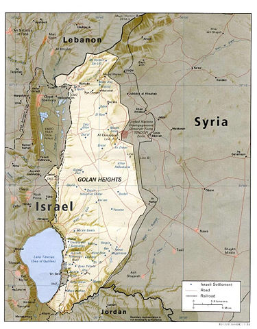
cia map found at www.lib.utexas.edu/maps/syria.html en:Category:Maps of the Golan Heights |
| Source |
Originally from en.wikipedia; description page is/was here. |
| Date |
2006-10-04 (first version); 2007-05-25 (last version) |
| Author |
Original uploader was Amoruso at en.wikipedia Later versions were uploaded by Dp roberson at en.wikipedia. |
Permission
( Reusing this image) |
PD-USGOV-CIA.
|
License information
 |
This image is a work of a Central Intelligence Agency employee, taken or made during the course of the person's official duties. As a Work of the United States Government, all images created or made by the CIA are in the public domain, with the exception of classified information. |
 |
Original upload log
(All user names refer to en.wikipedia)
- 2007-05-25 16:18 Dp roberson 1022×1308×8 (196375 bytes) cia map found at www.lib.utexas.edu/maps/syria.html
- 2006-10-04 19:57 Amoruso 1022×1308×8 (236546 bytes) {{PD-USGov-CIA}} cia map found at www.lib.utexas.edu/maps/syria.html
File history
Click on a date/time to view the file as it appeared at that time.
|
|
Date/Time |
Dimensions |
User |
Comment |
| current |
15:12, 11 June 2007 |
1,022×1,308 (192 KB) |
Liftarn |
|
File links
The following pages on Schools Wikipedia link to this image (list may be incomplete):


