Image:EthioPlaceNamesBlank.png
From Wikipedia, the free encyclopedia
Size of this preview: 480 × 479 pixels
Full resolution (1,028 × 1,026 pixels, file size: 451 KB, MIME type: image/png)
Summary
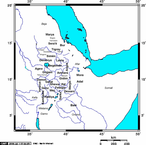
Created by me ( Yom). Map of Medieval Ethiopian provinces in large bold lettering, sub-provinces in small lettering, and neighboring tribes in italics (not part of Ethiopia in Medieval times - some may have had their own kingdoms).
Licensing
| |
I, the creator of this work, hereby grant the permission to copy, distribute and/or modify this document under the terms of the GNU Free Documentation License, Version 1.2 or any later version published by the Free Software Foundation; with no Invariant Sections, no Front-Cover Texts, and no Back-Cover Texts. Subject to disclaimers. |
File history
Click on a date/time to view the file as it appeared at that time.
| Date/Time | Dimensions | User | Comment | |
|---|---|---|---|---|
| current | 08:03, 3 July 2006 | 1,028×1,026 (451 KB) | Yom ( Talk | contribs) | (Created by me ( Yom). Map of Medieval Ethiopian provinces and neighboring tribes (a few like Kefa were not part of Ethiopia until after Medieval times, while others, e.g. the Muslim southcentral and southeastern states were often in rebellion ) |
| revert | 08:01, 3 July 2006 | 1,028×1,026 (146 KB) | Yom ( Talk | contribs) | (Created by me ( Yom). Map of Medieval Ethiopian provinces and neighboring tribes (a few like Kefa were not part of Ethiopia until after Medieval times, while others, e.g. the Muslim southcentral and southeastern states were often in rebellion ) |
See the setup instructions for more information.
File links
The following pages on Schools Wikipedia link to this image (list may be incomplete):
Categories: Self-published work