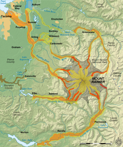
Image:Mount Rainier Hazard Map-en.svg
From Wikipedia, the free encyclopedia
Mount_Rainier_Hazard_Map-en.svg (SVG file, nominally 1,059 × 1,266 pixels, file size: 2.46 MB)
| |
This is a file from the Wikimedia Commons. The description on its description page there is shown below. |
Picture keys
██ Lava flow and pyroclastic flows
██ Electron Mudflow-sized event (generally large in size)
██ National Lahar-sized event (generally moderate in size)
██ Lahars not necessarily associated to volcanism (generally small)
██ Rooding after lahar event
██ Potential area of inundation from failure of Alder Dam
|
|
County boundary |
|
|
Mount Rainier National Park boundary |
Description
| Description |
English: Hazard map around the Mount Rainier, state of Washington, United States. Français : Carte des risques liés au volcanisme du Mont Rainier, état de Washington, États-Unis. |
||
|---|---|---|---|
| Source |
Own work.
Softwares used :
Others :
|
||
| Date |
2007-12-10 |
||
| Author |
Sémhur · ✉· ✍· |
||
| Permission ( Reusing this image) |
see below |
||
| Other versions |
|
 |
This SVG file uses embedded text that can be easily translated into your language. Learn more. For SVG images, you can use this page to translate it into your language. العربية | Català | Dansk | Deutsch | English | Esperanto | Español | Français | Galego | Italiano | 日本語 | Lietuvių | Magyar | Nederlands | Polski | Português | Русский | Svenska | Українська | +/- |
| |
This vector image was created with Inkscape. |
Licensing
 |
This image is in the public domain because it contains materials that originally came from the United States Geological Survey, an agency of the United States Department of Interior. For more information, see the official USGS copyright policy |
|
File history
Click on a date/time to view the file as it appeared at that time.
| Date/Time | Dimensions | User | Comment | |
|---|---|---|---|---|
| current | 10:18, 20 December 2007 | 1,059×1,266 (2.46 MB) | Sémhur | (Correcting some labels) |
| 11:17, 10 December 2007 | 1,059×1,266 (2.46 MB) | Sémhur | (== Picture keys == {{legend|#aaa788|Lava flow and pyroclastic flows}} {{legend|#cdcb54|Electron Mudflow-sized event (generally large in size)}} {{legend|#e59b36|National Lahar-sized event (generally moderate in size)}} {{legend|#e45218|Lahars not necessar) |