Image:Map of Warsaw Pact countries.png
From Wikipedia, the free encyclopedia
No higher resolution available.
Map_of_Warsaw_Pact_countries.png (607 × 207 pixels, file size: 9 KB, MIME type: image/png)
| |
This is a file from the Wikimedia Commons. The description on its description page there is shown below. |
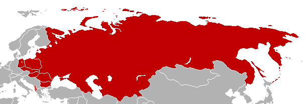
Map of nations that signed the Warsaw Pact.
| |
Permission is granted to copy, distribute and/or modify this document under the terms of the GNU Free Documentation License, Version 1.2 or any later version published by the Free Software Foundation; with no Invariant Sections, no Front-Cover Texts, and no Back-Cover Texts. Subject to disclaimers. |
Summary
A map of the Warsaw Pact countries by Biekko, derived from an old version of en:Image:Nato map.png.
Licensing
 |
Permission is granted to copy, distribute and/or modify this document under the terms of the GNU Free Documentation license, Version 1.2 or any later version published by the Free Software Foundation; with no Invariant Sections, no Front-Cover Texts, and no Back-Cover Texts. A copy of the license is included in the section entitled " GNU Free Documentation license". Aragonés | العربية | Asturianu | Беларуская (тарашкевіца) | Български | বাংলা | ইমার ঠার/বিষ্ণুপ্রিয়া মণিপুরী | Brezhoneg | Bosanski | Català | Cebuano | Česky | Dansk | Deutsch | Ελληνικά | English | Esperanto | Español | Eesti | Euskara | فارسی | Suomi | Français | Gaeilge | Galego | עברית | Hrvatski | Magyar | Bahasa Indonesia | Ido | Íslenska | Italiano | 日本語 | ქართული | ភាសាខ្មែរ | 한국어 | Kurdî / كوردی | Latina | Lëtzebuergesch | Lietuvių | Bahasa Melayu | Nnapulitano | Nederlands | Norsk (nynorsk) | Norsk (bokmål) | Occitan | Polski | Português | Română | Русский | Slovenčina | Slovenščina | Shqip | Српски / Srpski | Svenska | తెలుగు | ไทย | Tagalog | Türkçe | Українська | اردو | Tiếng Việt | Volapük | Yorùbá | 中文(简体) | 中文(繁體) | +/- |
 |
This map image should be recreated using vector graphics as an SVG file. This has several advantages; see Commons:Media for cleanup for more information. If an SVG form of this image is already available, please upload it. After uploading an SVG, replace this template with {{ vector version available|new image name.svg}}. |
|
العربية | Български | Català | Česky | Dansk | Deutsch | English | Esperanto | Español | Français | Galego | 한국어 | Italiano | Magyar | Lietuvių | Nederlands | 日本語 | Polski | Português | Română | Русский | Suomi | Svenska | Türkçe | Українська | 中文(繁體) | 中文(简体) | +/- |
|
File history
Click on a date/time to view the file as it appeared at that time.
| Date/Time | Dimensions | User | Comment | |
|---|---|---|---|---|
| current | 13:15, 28 June 2008 | 607×207 (9 KB) | Shibo77 | ({{Information |Description= |Source= |Date= |Author= |Permission= |other_versions= }}) |
| 12:21, 17 June 2008 | 607×207 (9 KB) | Shibo77 | ({{Information |Description= |Source= |Date= |Author= |Permission= |other_versions= }}) | |
| 14:13, 21 January 2008 | 607×207 (7 KB) | Aivazovsky | ({{Information |Description= |Source= |Date= |Author= |Permission= |other_versions= }} ) | |
| 13:47, 21 January 2008 | 607×207 (7 KB) | Aivazovsky | ({{Information |Description= |Source= |Date= |Author= |Permission= |other_versions= }} ) | |
| 22:56, 9 April 2007 | 602×219 (7 KB) | Aivazovsky | ||
| 01:26, 14 December 2004 | 596×219 (9 KB) | Ævar Arnfjörð Bjarmason |