Image:Satellite image of Cape peninsula.jpg
From Wikipedia, the free encyclopedia
Size of this preview: 640 × 404 pixels
Full resolution (2,184 × 1,377 pixels, file size: 1.46 MB, MIME type: image/jpeg)
| |
This is a file from the Wikimedia Commons. The description on its description page there is shown below. |
| |
This is a featured picture on German Wikipedia and is considered one of the finest images.
|
|
| Description |
Afrikaans: 'n Satellietbeeld van Suid-Afrika deur die Nasa geneem in Februarie 2000, met behulp van hul Landsat. Kaapstad en die Kaap die Goeie Hoop verskyn in die voorgrond van hierdie beeld. 'n Satellietfoto, wat deur Landsat geneem is, word met data oor die hoogte bo seevlak van die betrokke gebiede (saamgestel deur die Shuttle Radar Topography Mission (SRTM)) gekombineer om hierdie saamgestelde beeld te vorm. Die middestad is in Tafelbaai geleë, naby Tafelberg. Tafelberg is 1 086 meter hoog en bestaan uit sandsteen en graniet. Die groot baai, wat soos 'n gat in die vasteland lyk, is Valsbaai. Die foto is deur die NASA geskep en die oorspronklike beeld is te vinde by hierdie skakel.
Deutsch: Satellitenbild des Kap der Guten Hoffnung, erstellt aus Bildern von Landsat und Daten der SRT-Mission des NASA Spaceshuttle Endeavor vom Februar 2000. Kapstadt und das Kap sind im Vordergrund der perspektivischen Ansicht zu sehen. Die perspektivische Ansicht wurde künstlich aus Fotografien und Radardaten zusammengesetzt.
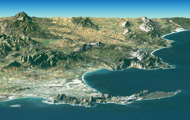
English: PIA04961: Cape Town, South Africa, Perspective View, Landsat Image over SRTM Elevation. Cape Town and the Cape of Good Hope, South Africa, appear in the foreground of this perspective view generated from a Landsat satellite image and elevation data from the Shuttle Radar Topography Mission (SRTM). The city centre is located at Table Bay (at the lower left), adjacent to Table Mountain, a 1,086-meter (3,563-foot) tall sandstone and granite natural landmark. The large bay facing right (South) is False Bay.
The perspective is computer generated, combining a photograph with elevation data collected using radar. This Landsat and SRTM perspective view uses a 2-times vertical exaggeration to enhance topographic expression. The back edges of the data sets form a false horizon and a false sky was added. Colors of the scene were enhanced by image processing but are the natural colour band combination from the Landsat satellite. |
|---|---|
| Source |
8.727 MB TIFF ALSO AVAILABLE: http://photojournal.jpl.nasa.gov/catalog/PIA04961 |
| Date |
February 2007 |
| Author |
NASA |
| Permission ( Reusing this image) |
see below
|
| |
This image or video was catalogued by Jet Propulsion Lab of the United States National Aeronautics and Space Administration (NASA) under Photo ID: PIA04961. This tag does not indicate the copyright status or the source of the attached work. A normal copyright tag and a source are still required. See Commons:Licensing for more information. |
Licensing
 |
This file is in the public domain because it was created by NASA. NASA copyright policy states that "NASA material is not protected by copyright unless noted". ( NASA copyright policy page or JPL Image Use Policy). Deutsch | English | Español | Français | Galego | Nederlands | Português | Русский | 中文(简体) | 中文(繁體) | +/- |
|
 |
Warnings:
|
File history
Click on a date/time to view the file as it appeared at that time.
| Date/Time | Dimensions | User | Comment | |
|---|---|---|---|---|
| current | 07:32, 28 April 2005 | 2,184×1,377 (1.46 MB) | Julien Carnot | ({{PD-USGov-NASA}} NASA satellite image of South Africa taken by Landsat in February 2000. Cape Town and the Cape of Good Hope, South Africa, appear in the foreground of this perspective view. The city centre is located at Table Bay (at th) |
File links
Metadata
This file contains additional information, probably added from the digital camera or scanner used to create or digitize it. If the file has been modified from its original state, some details may not fully reflect the modified file.
| Orientation | Normal |
|---|---|
| Horizontal resolution | 72 dpi |
| Vertical resolution | 72 dpi |
| Software used | Adobe Photoshop CS Macintosh |
| File change date and time | 16:07, 16 July 2004 |
| Colour space | 65535 |