Image:Mercury weird terrain.jpg
From Wikipedia, the free encyclopedia
No higher resolution available.
Mercury_weird_terrain.jpg (400 × 368 pixels, file size: 61 KB, MIME type: image/jpeg)
 |
This is a candidate to be copied to the Wikimedia Commons. Appropriately licensed media are more accessible to other Wikimedia projects if placed on Commons. Any user may perform this move - please see Moving images to the Commons for more information. Please remove this tag after this image has been copied to Commons. Copy to Commons via CommonsHelper |
Source: http://pds.jpl.nasa.gov/planets/captions/mercury/mercter.htm (subsequently cropped) Also appears at the NASA Planetary Photojournal: http://photojournal.jpl.nasa.gov/catalog/PIA02445
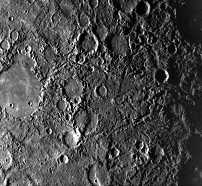
extract from the image's caption:
Weird terrain best describes this hilly, lineated region of Mercury. Scientists note that this area is at the antipodal point to the large Caloris basin. The shock wave produced by the Caloris impact may have been reflected and focused to the antipodal point, thus jumbling the crust and breaking it into a series of complex blocks. The area covered is about 800 km (497 mi) on a side.
 |
This file is in the public domain because it was created by NASA. NASA copyright policy states that "NASA material is not protected by copyright unless noted". ( NASA copyright policy page or JPL Image Use Policy)
|
File history
Click on a date/time to view the file as it appeared at that time.
| Date/Time | Dimensions | User | Comment | |
|---|---|---|---|---|
| current | 13:24, 23 March 2007 | 400×368 (61 KB) | Deuar ( Talk | contribs) | ('''Source''': http://pds.jpl.nasa.gov/planets/captions/mercury/mercter.htm (subsequently cropped) Also appears at the NASA Planetary Photojournal: http://photojournal.jpl.nasa.gov/catalog/PIA02445 ''extract from the image's caption:'' Weird terrain bes) |
See the setup instructions for more information.