From Wikipedia, the free encyclopedia
 Size of this preview: 577 × 480 pixels
 Full resolution (1,150 × 956 pixels, file size: 213 KB, MIME type: image/png)
 |
This is a file from the Wikimedia Commons. The description on its description page there is shown below.Commons is a freely licensed media file repository. You can help.
|
Summary
| Description |
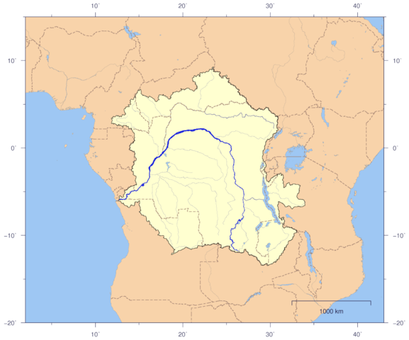
English: Course and Watershed of the Congo and Lualaba River with political boundaries.
Deutsch: Verlauf und Einzugsgebiet von Kongo und Lualaba mit Staatsgrenzen.
|
| Source |
The map has been created with the Generic Mapping Tools: http://gmt.soest.hawaii.edu/ using additional public comain data from the VMAP0 data set. |
| Date |
2007-01-02 |
| Author |
Imagico |
Permission
( Reusing this image) |

  |
This file is licensed under the Creative Commons Attribution ShareAlike 2.5 License. In short: you are free to share and make derivative works of the file under the conditions that you appropriately attribute it, and that you distribute it only under a license identical to this one. Official license |
|
| Other versions |
Image:CongoLualaba_watershed_plain.png |
Licensing
I, the copyright holder of this work, hereby publish it under the following license:

  |
This file is licensed under the Creative Commons Attribution ShareAlike 2.5 License. In short: you are free to share and make derivative works of the file under the conditions that you appropriately attribute it, and that you distribute it only under a license identical to this one. Official license |
|
File history
Click on a date/time to view the file as it appeared at that time.
|
|
Date/Time |
Dimensions |
User |
Comment |
| current |
21:02, 3 January 2007 |
1,150×956 (213 KB) |
Imagico |
|
File links
The following pages on Schools Wikipedia link to this image (list may be incomplete):
