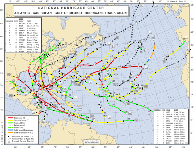
Image:2005 Atlantic hurricane season map.png
From Wikipedia, the free encyclopedia

Size of this preview: 625 × 480 pixels
Full resolution (4,035 × 3,096 pixels, file size: 671 KB, MIME type: image/png)
File history
Click on a date/time to view the file as it appeared at that time.
| Date/Time | Dimensions | User | Comment | |
|---|---|---|---|---|
| current | 00:26, 11 April 2006 | 4,035×3,096 (671 KB) | Tom | (Reverted to earlier revision) |
| 00:24, 11 April 2006 | 3,171×2,450 (1.02 MB) | Tom | (Reverted to earlier revision) | |
| 00:14, 11 April 2006 | 4,035×3,096 (671 KB) | Tom | (updating information to include new storm; higher res) | |
| 00:14, 11 April 2006 | 3,171×2,450 (1.02 MB) | Titoxd | (Updated copy for Unnamed Subtropical Storm, derived from http://www.nhc.noaa.gov/tracks/2005atl.pdf at 300% magnification) | |
| 22:50, 7 April 2006 | 3,031×2,312 (481 KB) | Tom | (much higher resolution) | |
| 22:00, 7 April 2006 | 1,266×967 (169 KB) | Tom | (trimming) | |
| 21:53, 7 April 2006 | 1,309×1,007 (198 KB) | Tom | (== Summary == http://www.nhc.noaa.gov/2005atlan.shtml From the National Hurricane Centre == Licensing == {{PD-USGov-DOC-NOAA}} Category:2005 Atlantic hurricane season) |
File links
The following pages on Schools Wikipedia link to this image (list may be incomplete):


