Image:Amur watershed.png
From Wikipedia, the free encyclopedia
No higher resolution available.
Amur_watershed.png (300 × 301 pixels, file size: 50 KB, MIME type: image/png)
| |
This is a file from the Wikimedia Commons. The description on its description page there is shown below. |
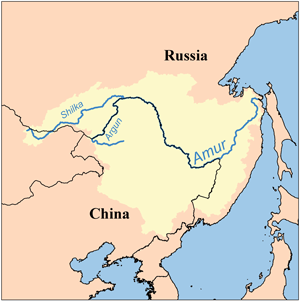
This is a map of the Amur River Watershed. I, Karl Musser, created it based on USGS data.
|
File history
Click on a date/time to view the file as it appeared at that time.
| Date/Time | Dimensions | User | Comment | |
|---|---|---|---|---|
| current | 18:28, 1 April 2008 | 300×301 (50 KB) | Kmusser | (added labels for tribs) |
| 12:54, 11 April 2006 | 300×300 (16 KB) | Kmusser | ||
| 12:49, 11 April 2006 | 200×200 (10 KB) | Kmusser | (This is a map of the Amur River Watershed. I, Karl Musser, created it based on USGS data. {{GFDL}} Category:Maps of rivers) |
File links
The following pages on Schools Wikipedia link to this image (list may be incomplete):