Image:USGS Sunda Trench.JPG
From Wikipedia, the free encyclopedia
No higher resolution available.
USGS_Sunda_Trench.JPG (611 × 461 pixels, file size: 62 KB, MIME type: image/jpeg)
| |
This is a file from the Wikimedia Commons. The description on its description page there is shown below. |
| Description |
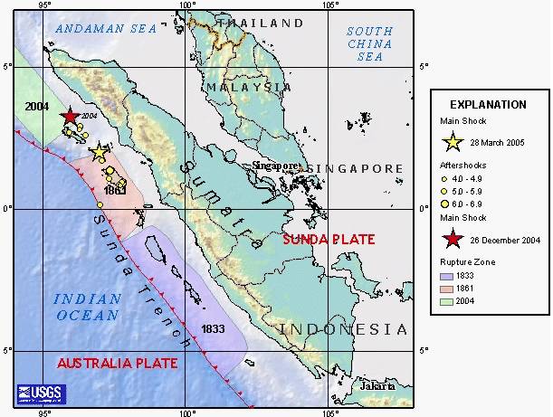
en:USGS image depicting en:earthquake zones for the en:Sunda Trench - en:1833, en:1861, en:26 December en:2004 Indian Ocean earthquake, and en:28 March en:2005 Sumatran earthquake. |
|---|---|
| Source |
Originally from en.wikipedia; description page is/was here. |
| Date |
2005-03-31 (original upload date) |
| Author |
Original uploader was Peter Ellis at en.wikipedia |
| Permission ( Reusing this image) |
PD-USGOV-INTERIOR-USGS.
|
License information
 |
This image is in the public domain because it contains materials that originally came from the United States Geological Survey, an agency of the United States Department of Interior. For more information, see the official USGS copyright policy |
|
Original upload log
(All user names refer to en.wikipedia)
- 2005-03-31 03:57 Peter Ellis 611×461×8 (63844 bytes) [[USGS]] image depicting [[earthquake]] zones for the [[Sunda Trench]] - [[1833]], [[1861]], [[26 December]] [[2004 Indian Ocean earthquake]], and [[28 March]] [[2005 Sumatran earthquake]]. {{PD-USGov-Interior-USGS}}
File history
Click on a date/time to view the file as it appeared at that time.
| Date/Time | Dimensions | User | Comment | |
|---|---|---|---|---|
| current | 11:34, 9 October 2007 | 611×461 (62 KB) | Matthiasb | ({{Information |Description= en:USGS image depicting en:earthquake zones for the en:Sunda Trench - en:1833, en:1861, en:26 December en:2004 Indian Ocean earthquake, and en:28 March en:2005 Sumatran earthquake. |S) |
File links
The following pages on Schools Wikipedia link to this image (list may be incomplete):