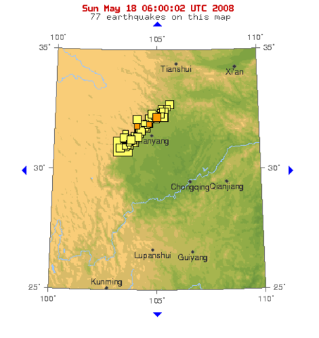
Image:USGS map at 30 deg N lat, 105 deg E long (2008-05-18).png
From Wikipedia, the free encyclopedia
Size of this preview: 453 × 480 pixels
Full resolution (471 × 499 pixels, file size: 28 KB, MIME type: image/png)
| |
This is a file from the Wikimedia Commons. The description on its description page there is shown below. |
move approved by: User:LERK
This image was moved from Image:USGS map at 30°N,105°E (2008-05-18).png
| Description |
USGS map at 30°N,105°E |
|---|---|
| Source |
http://earthquake.usgs.gov/eqcenter/recenteqsww/Maps/10/105_30.php, (retrieved 2008-05-18, 06:00:02 UTC) |
| Date |
2008-05-18 |
| Author |
USGS |
| Permission ( Reusing this image) |
see below
|
Licensing
 |
This image is in the public domain because it contains materials that originally came from the United States Geological Survey, an agency of the United States Department of Interior. For more information, see the official USGS copyright policy |
|
File history
| date/time | username | resolution | size | edit summary | |
|---|---|---|---|---|---|
| 06:40, 18 May 2008 | User:TakuyaMurata | <a href=" http://upload.wikimedia.org/wikipedia/commons/c/cb/USGS_map_at_30%C2%B0N%2C105%C2%B0E_%282008-05-18%29.png"><img alt="Thumbnail for version as of 06:40, 18 May 2008" src=" http://upload.wikimedia.org/wikipedia/commons/thumb/c/cb/USGS_map_at_30%C2%B0N%2C105%C2%B0E_%282008-05-18%29.png/113px-USGS_map_at_30%C2%B0N%2C105%C2%B0E_%282008-05-18%29.png" width="113" height="120" border="0" /></a> | 471×499 | 28 KB | {{Information |Description=USGS map at 30°N,105°E |Source=http://earthquake.usgs.gov/eqcenter/recenteqsww/Maps/10/105_30.php, (retrieved 2008-05-18 at 06:00:02 UTC) |Date= 2008-05-18 |Author=USGS |Permission= |other_versions= }} |
File history
Click on a date/time to view the file as it appeared at that time.
| Date/Time | Thumbnail | Dimensions | User | Comment | |
|---|---|---|---|---|---|
| current | 18:25, 8 September 2008 |  |
471×499 (28 KB) | BetacommandBot | (move approved by: User:LERK This image was moved from Image:USGS map at 30°N,105°E (2008-05-18).png {{Information |Description=USGS map at 30°N,105°E |Source=http://earthquake.usgs.gov/eqcenter/recenteqsww/Maps/10/105_30.php, (retrieved 200) |
File links
The following pages on Schools Wikipedia link to this image (list may be incomplete):