Image:Africa Koppen Map.png
From Wikipedia, the free encyclopedia
Size of this preview: 396 × 479 pixels
Full resolution (1,500 × 1,816 pixels, file size: 847 KB, MIME type: image/png)
| |
This is a file from the Wikimedia Commons. The description on its description page there is shown below. |
| Peel, M. C. and Finlayson, B. L. and McMahon, T. A. (2007). "Updated world map of the Köppen-Geiger climate classification". Hydrol. Earth Syst. Sci. 11: 1633-1644. |
|
Legend
|
██ Af: equatorial climate , tropisch regenwoudklimaat |
|
██ Am: monsunklima, monsoon climate, nl:moessonklimaat |
|
██ Aw: tropical savanna climate, tropisch savanneklimaat |
|
██ BWh: warm desert climate, warm woestijnklimaat |
|
██ Bwk: cold desert climate, koud woestijnklimaat |
|
██ Bsh: warm semi-arid climate, warm steppeklimaat |
|
██ Bsk: cold semi-arid climate, koud steppeklimaat |
|
██ Csa: wärme mittelmeerklima, warm mediterranean climate, warm mediterraan klimaat |
|
██ Csb: gemäßigte mittelmeerklima, temperate mediterranean climate, gematigd mediterraan klimaat |
|
██ Cwa: humid subtropical climate, warm chinaklimaat (gematigd savanneklimaat) |
|
██ Cwb: gematigd chinaklimaat |
|
██ Cwc: koel chinaklimaat |
|
██ Cfa: wärme seeklima, warm oceanic climate/ humid subtropical climate, warm zeeklimaat |
|
██ Cfb: gemäßigte seeklima, temperate oceanic climate, gematigd zeeklimaat |
|
██ Cfc: kühle seeklima, cool oceanic climate, koel zeeklimaat |
|
██ Dsa: wärme kontinentalklima, warm continental climate/ mediterranean continental climate, warm landklimaat/ mediterraan landklimaat |
|
██ Dsb: gemäßigte kontinentalklima, temperate continental climate/ mediterranean continental climate, gematigd landklimaat/ mediterraan landklimaat |
|
██ Dsc: kühle kontinentalklima, cool continental climate, koel landklimaat |
|
██ Dsd: kalte kontinentalklima, cold continental climate, koud landklimaat |
|
██ Dwa: wärme kontinentalklima, warm continental climate/ humid continental climate, warm landklimaat |
|
██ Dwb: gemäßigte kontinentalklima, temperate continental climate/ humid continental climate, gematigd landklimaat |
|
██ Dwc: kühle kontinentalklima, cool continental climate/ subarctic climate, koel landklimaat/ subarctisch klimaat |
|
██ Dwd: kalte kontinentalklima, cold continental climate/ subarctic climate, koud landklimaat/ subarctisch klimaat |
|
██ Dfa: wärme kontinentalklima, warm continental climate/ humid continental climate, warm landklimaat |
|
██ Dfb: gemäßigte kontinentalklima, temperate continental climate/ humid continental climate, gematigd landklimaat |
|
██ Dfc: kühle kontinentalklima, cool continental climate/ subarctic climate, koel landklimaat/ subarctisch klimaat |
|
██ Dfd: kalte kontinentalklima, cold continental climate/ subarctic climate, koud landklimaat/ subarctisch klimaat |
|
██ ET: tundraklima, tundra climate, toendraklimaat (incl. hooggebergteklimaat (EH)) |
|
██ EF: eisklimate, ice cap climate, ijsklimaat |
Information
| Description |
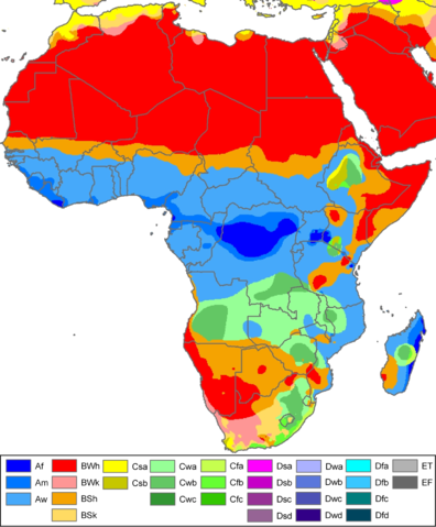
Climate map of Africa (from the " Updated world map of the Köppen-Geiger climate classification"). |
|---|---|
| Source |
Hydrology and Earth System Sciences: "Updated world map of the Köppen-Geiger climate classification" (Supplement) - Original file was a JPG-file, this file is has been converted to a PNG-file, without extra modifications, by me (Jeroenvrp). |
| Date |
October 12th 2007 |
| Author |
Peel, M. C., Finlayson, B. L., and McMahon, T. A. |
| Permission ( Reusing this image) |
Yes, by e-mail (please ask user:jeroenvrp for the e-mails).
|
Related maps
User Jeroenvrp made for these continents and areas a cropped and resized version:
- Africa_Koppen_Map.png
User LordToran made from the same data these maps:
Licence
| |
This file is licensed under the Creative Commons Attribution ShareAlike 3.0 Unported License. In short: you are free to share and make derivative works of the file under the conditions that you appropriately attribute it, and that you distribute it only under a license compatible with this one. العربية | Català | Česky | Deutsch | Ελληνικά | English | Esperanto | Español | فارسی | Français | Italiano | עברית | 日本語 | 한국어 | Magyar | Nederlands | Plattdüütsch | Polski | Português | Русский | Svenska | Tiếng Việt | Українська | +/- |
File history
Click on a date/time to view the file as it appeared at that time.
| Date/Time | Dimensions | User | Comment | |
|---|---|---|---|---|
| current | 22:51, 12 October 2007 | 1,500×1,816 (847 KB) | Jeroencommons | (Citation: '''Peel, M. C., Finlayson, B. L., and McMahon, T. A.: Updated world map of the Köppen-Geiger climate classification, Hydrol. Earth Syst. Sci., 11, 1633-1644, 2007.''' {{Information |Description= Climate map of Africa (from the "[[:Image:Worl) |