From Wikipedia, the free encyclopedia
 |
This is a file from the Wikimedia Commons. The description on its description page there is shown below.Commons is a freely licensed media file repository. You can help.
|
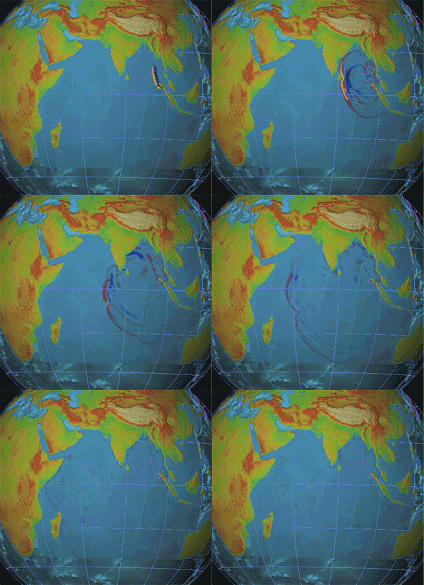
Simulation of the 2004 Indonesia Tsunami.
|
|
This is a featured picture on Wikimedia Commons: it is considered one of our finest images.
If you have an image of similar quality that can be published under a suitable copyright license, be sure to upload it, tag it, and nominate it. |
 |
 |
This image was selected as a picture of the day for April 7, 2006. It was captioned as followed: English: Animation of 2004 Indonesia tsunami
Česky: Animace tsunami v Indonésii v roce 2004.
Deutsch: Animation des in Indonesien entstandenen Tsunami von 2004
English: Animation of 2004 Indonesia tsunami
Español: Animación ilustrando la propagación de los tsunamis por el Terremoto del Océano Índico de 2004
Français : Animation du tsunami Indien de 2004
Galego: Animación do tsunami de Indonesia de 2004
Magyar: A 2004-es Indonéziai cunami modellezése
Italiano: Animazione rappresentante lo Tsunami del 2004.
日本語: 2004年のスマトラ島沖地震で起きた津波の動き
Nederlands: Animatie van de Aardbeving in de Indische Oceaan in 2004
Norsk (nynorsk): Animasjon av jordskjelvet i Indiahavet i 2004
Polski: Animacja przedstawiająca fale tsunami podczas trzęsienia ziemi na Oceanie Indyjskim w 2004
Português: Animação ilustrando a propagação dos tsunamis, no terremonto do Oceano Índico de 2004.
Русский: Цунами в Индийском океане 26 декабря 2004 года
Svenska: Animering av tsunamivågorna vid jordbävningen i Indiska oceanen 2004.
ไทย: ภาพเคลื่อนไหวแสดง คลื่นสึนามิสุมาตรา พ.ศ. ๒๕๔๗
中文(简体): 2004年印度洋海啸示意图
|
| Description |
English: Animation of 2004 Indonesia tsunami
Source: NOAA video Animation provided by Vasily V. Titov, Associate Director, Tsunami Inundation Mapping Efforts (TIME), NOAA/PMEL - UW/JISAO, USA.
Français : Animation du Raz de marée du 26 décembre 2004
Source: NOAA video
|
| Source |
NOAA |
| Date |
|
| Author |
Animation fournie par Vasily V. Titov, Sous-directeur du Service de Cartographie des Raz de marée et Inondations (TIME) du NOAA, aux USA |
Permission
( Reusing this image) |
 |
This image is in the public domain because it contains materials that originally came from the U.S. National Oceanic and Atmospheric Administration, taken or made during the course of an employee's official duties. |
|
|
Originally uploaded to en: by User:Malu5531 at December 30, 2004. It has had several more uploads, and the full upload history is shown below.
    * (del) (cur) 22:02, 10 August 2005 . . Riobranden (3151894 bytes) (Reverted to earlier revision)
    * (del) (rev) 22:01, 10 August 2005 . . Riobranden (1148870 bytes) (Reverted to earlier revision)
    * (del) (rev) 18:45, 4 May 2005 . . Menphrad (3151894 bytes) (Reverted to earlier revision)
    * (del) (rev) 05:31, 5 January 2005 . . Cantus (1148870 bytes) (Reverted to earlier revision)
    * (del) (rev) 15:50, 1 January 2005 . . Brhaspati (749420 bytes) (Reverted to earlier revision)
    * (del) (rev) 23:17, 30 December 2004 . . Cantus (1148870 bytes) (300px)
    * (del) (rev) 16:17, 30 December 2004 . . Malu5531 (749420 bytes) (lower resolution to lower the size)
    * (del) (rev) 16:08, 30 December 2004 . . Malu5531 (1585302 bytes) (Half the size and half the frames...)
    * (del) (rev) 16:02, 30 December 2004 . . Malu5531 (3151894 bytes)
    * (del) (rev) 15:54, 30 December 2004 . . Malu5531 (3151894 bytes) (NOAA animation of Indonesia tsunami)
---
File history
Click on a date/time to view the file as it appeared at that time.
|
|
Date/Time |
Dimensions |
User |
Comment |
| current |
05:16, 21 May 2006 |
300×276 (1.1 MB) |
Cantus |
|
|
|
00:04, 29 March 2006 |
300×276 (2.93 MB) |
Dbenbenn |
|
|
|
13:12, 5 September 2005 |
304×280 (3.01 MB) |
Jon Harald Søby |
|
|
|
04:37, 5 September 2005 |
300×276 (1.1 MB) |
Cantus |
|
|
|
10:54, 21 August 2005 |
304×280 (3.01 MB) |
Jon Harald Søby |
|
File links
The following pages on Schools Wikipedia link to this image (list may be incomplete):


