Image:World in 300 CE.PNG
From Wikipedia, the free encyclopedia
Size of this preview: 640 × 326 pixels
Full resolution (4,000 × 2,036 pixels, file size: 1.69 MB, MIME type: image/png)
| |
This is a file from the Wikimedia Commons. The description on its description page there is shown below. |
Summary
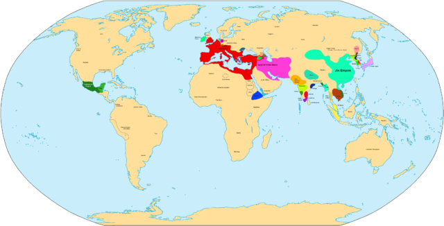
| Description |
Map of the World in 300 CE. |
|---|---|
| Source |
self-made |
| Date | |
| Author |
Javierfv1212 |
| Permission ( Reusing this image) |
see below
|
| Maps of world history | |
| BC |
2000 · 1500 · 1000 · 500 · 400 · 323 · 300 · 200 · 100 · 50 |
|
|
|
| AD |
1 · 50 · 100 · 200 · 250 · 300 · 400 · 450 · 500 · 600 · 700 · 750 · 800 · 820 · 900 · 1000 · 1300 · 1492 · 1550 · 1660 · 1754 · 1822 · 1885 · 1898 · 1914 · 1920 · 1936 · 1938 · 1945 · 1959 · 1959 · 1974 · 1980 · 2007 |
| (this template: · view · discuss ) | |
 |
This map image should be recreated using vector graphics as an SVG file. This has several advantages; see Commons:Media for cleanup for more information. If an SVG form of this image is already available, please upload it. After uploading an SVG, replace this template with {{ vector version available|new image name.svg}}. |
|
العربية | Български | Català | Česky | Dansk | Deutsch | English | Esperanto | Español | Français | Galego | 한국어 | Italiano | Magyar | Lietuvių | Nederlands | 日本語 | Polski | Português | Română | Русский | Suomi | Svenska | Türkçe | Українська | 中文(繁體) | 中文(简体) | +/- |
|
Licensing
 |
I, the copyright holder of this work, hereby release it into the public domain. This applies worldwide. In case this is not legally possible: Afrikaans | Alemannisch | Aragonés | العربية | Asturianu | Български | Català | Cebuano | Česky | Cymraeg | Dansk | Deutsch | Eʋegbe | Ελληνικά | English | Español | Esperanto | Euskara | Estremeñu | فارسی | Français | Galego | 한국어 | हिन्दी | Hrvatski | Ido | Bahasa Indonesia | Íslenska | Italiano | עברית | Kurdî / كوردی | Latina | Lietuvių | Latviešu | Magyar | Македонски | Bahasa Melayu | Nederlands | Norsk (bokmål) | Norsk (nynorsk) | 日本語 | Polski | Português | Ripoarisch | Română | Русский | Shqip | Slovenčina | Slovenščina | Српски / Srpski | Suomi | Svenska | ไทย | Tagalog | Türkçe | Українська | Tiếng Việt | Walon | 中文(简体) | 中文(繁體) | zh-yue-hant | +/- |
File history
Click on a date/time to view the file as it appeared at that time.
| Date/Time | Dimensions | User | Comment | |
|---|---|---|---|---|
| current | 01:12, 4 November 2007 | 4,000×2,036 (1.69 MB) | Javierfv1212 | ({{Information |Description= |Source=self-made |Date= |Author= Javierfv1212 |Permission= |other_versions= }} Category:Maps of the world showing history) |