From Wikipedia, the free encyclopedia
 |
This is a file from the Wikimedia Commons. The description on its description page there is shown below.Commons is a freely licensed media file repository. You can help.
|
| WikiProject India Maps |
Delhi locator map |
| Description |
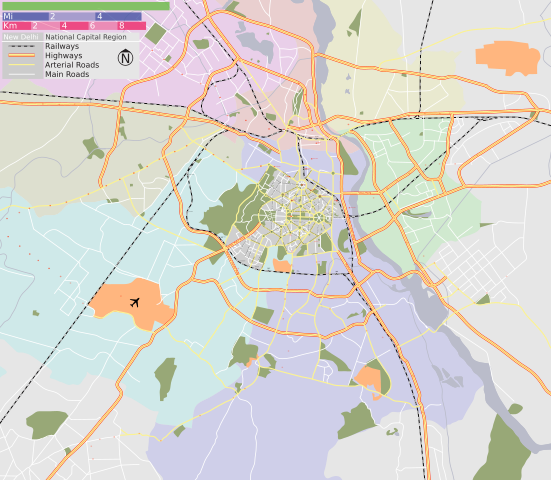
Map of New Delhi and Delhi district, with major roads, railways and water bodies. |
| Source |
Delhi Metro |
| Date |
3 Mar 07 |
| Author |
|
|
This Image was created by User:PlaneMad.
- If you would like special permission to use the image please mail me at thePlaneMad@gmail.com or catch me at my Website
|
|
| Permission |
GFDL / Creative Commons - Share Alike |
SVG Support
This document is in the Scalable Vector Graphic format (SVG) and requires a supported browser (Opera 9, Firefox 2) or a SVG plugin for Internet Explorer and other browsers. SVG is an open source format, which means this map can be downloaded and modified/translated completely using a vector graphics editor like Adobe Illustrator or Inkscape (free) or a text editor such as Notepad.
| BLANK THUMBNAIL |
View large PNG |
View medium PNG |
SVG Plugin for Internet Explorer and other browsers |
| Click here (purge cache) and then CTRL+F5 to reload. Help? |
Try 1 Try 2 |
Try 1 Try 2 |
Adobe SVG plugin |
| Recommended browser |
More Help |
| Opera 9.1 |
List of SVG tools |
License
I, the copyright holder of this work, hereby publish it under the following licenses:
 |
Permission is granted to copy, distribute and/or modify this document under the terms of the GNU Free Documentation license, Version 1.2 or any later version published by the Free Software Foundation; with no Invariant Sections, no Front-Cover Texts, and no Back-Cover Texts. A copy of the license is included in the section entitled " GNU Free Documentation license".
Aragonés | العربية | Asturianu | Беларуская (тарашкевіца) | Български | বাংলা | ইমার ঠার/বিষ্ণুপ্রিয়া মণিপুরী | Brezhoneg | Bosanski | Català | Cebuano | Česky | Dansk | Deutsch | Ελληνικά | English | Esperanto | Español | Eesti | Euskara | فارسی | Suomi | Français | Gaeilge | Galego | עברית | Hrvatski | Magyar | Bahasa Indonesia | Ido | Íslenska | Italiano | 日本語 | ქართული | ភាសាខ្មែរ | 한국어 | Kurdî / كوردی | Latina | Lëtzebuergesch | Lietuvių | Bahasa Melayu | Nnapulitano | Nederlands | Norsk (nynorsk) | Norsk (bokmål) | Occitan | Polski | Português | Română | Русский | Slovenčina | Slovenščina | Shqip | Српски / Srpski | Svenska | తెలుగు | ไทย | Tagalog | Türkçe | Українська | اردو | Tiếng Việt | Volapük | Yorùbá | 中文(简体) | 中文(繁體) | +/- |
You may select the license of your choice.
|
Errata
If you notice a mistake on the map, please list them here. Please mention the name of the map to be corrected also.
 |
Textual information once visible in the image itself has been moved into the image metadata and/or image description page. This makes the image easier to reuse and more language-neutral, and makes the text easier to process and search for. Commons discourages placing visible textual information in images. All licenses accepted on Commons permit this type of modification as a derivative work. If attribution information was removed and the image is not public domain, replace this tag with {{ attribution metadata from licensed image}}.
Deutsch | English | Français | Italiano | Português | +/- |
File history
Click on a date/time to view the file as it appeared at that time.
|
|
Date/Time |
Dimensions |
User |
Comment |
| current |
16:06, 7 August 2008 |
1,430×1,245 (388 KB) |
Jarekt |
|
|
|
10:12, 12 March 2007 |
1,430×1,245 (389 KB) |
PlaneMad |
|
|
|
13:19, 9 March 2007 |
1,552×1,341 (371 KB) |
PlaneMad |
|
|
|
17:59, 3 March 2007 |
1,476×1,274 (227 KB) |
PlaneMad |
|
File links
The following pages on Schools Wikipedia link to this image (list may be incomplete):


