Image:Ph map manila.svg
From Wikipedia, the free encyclopedia
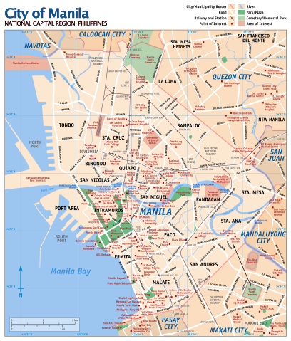
Ph_map_manila.svg (SVG file, nominally 764 × 897 pixels, file size: 3.09 MB)
| |
This is a file from the Wikimedia Commons. The description on its description page there is shown below. |
| This is a featured picture, which means that members of the community have identified it as one of the finest images on the English Wikipedia, adding significantly to its accompanying article. If you have a different image of similar quality, be sure to upload it using the proper free license tag, add it to a relevant article, and nominate it. |
| |
This is a featured picture on English Wikipedia and is considered one of the finest images.
|
|
Summary
| Description |
This is an SVG version of Media:Ph map manila large.png. Updated for 2006. |
|---|---|
| Source |
Own work |
| Date |
2007-01-01 |
| Author |
Eugene Alvin Villar ( User:Seav) |
| Permission ( Reusing this image) |
Own work |
| Other versions | Media:Ph map manila large.png |
Licensing
|

File history
Click on a date/time to view the file as it appeared at that time.
| Date/Time | Dimensions | User | Comment | |
|---|---|---|---|---|
| current | 12:16, 7 February 2007 | 764×897 (3.09 MB) | Seav | (Saved using Inkscape (to hopefully fix rendering issues)) |
| 13:09, 13 January 2007 | 765×897 (1.9 MB) | Seav | (Previous SVG was not being interpreted by Wikimedia's SVG "plug-in". Now it's not viewable in Firefox, though.) | |
| 17:10, 10 January 2007 | 765×897 (1.9 MB) | Seav | (Added N and E to coordinates) | |
| 16:24, 10 January 2007 | 765×897 (1.89 MB) | Seav | (Added north direction arrow and coordinate grid.) | |
| 22:55, 8 January 2007 | 765×897 (1.85 MB) | Seav | (removed outer black border (will not consistently show up in thumbnails); fixed map legend) | |
| 09:02, 7 January 2007 | 765×897 (1.85 MB) | Seav | (Primarily added map legend; added map subtitle; added 'Manila' label) | |
| 06:34, 6 January 2007 | 765×862 (1.79 MB) | Seav | (Corrected "Don Bosco Technical College" from "Don Bosco Technical Institute"; slightly reduced file size.) | |
| 05:06, 2 January 2007 | 765×862 (2.43 MB) | Seav | (Added xmlns and xmlns:xlink attributes to svg XML element so that it will be viewable in Mozilla Firefox. Added Copyright information in an XML comment element.) | |
| 04:35, 2 January 2007 | 765×862 (2.43 MB) | Seav | (Added missing point of interest labels.) | |
| 14:03, 1 January 2007 | 765×862 (2.38 MB) | Seav | (Removed extra SVG object.) | |
| 03:09, 1 January 2007 | 768×990 (2.38 MB) | Seav | (This is an SVG version of Image:Ph map manila large.png. Also updated for 2006.) |