Image:Paris RER.svg
From Wikipedia, the free encyclopedia
Paris_RER.svg (SVG file, nominally 3,540 × 2,913 pixels, file size: 689 KB)
| |
This is a file from the Wikimedia Commons. The description on its description page there is shown below. |
You can zoom! Use a software like Inkscape to edit, or like Opera or Mozilla Firefox to view.
Vous pouvez agrandir ! Utilisez un logiciel tel Inkscape pour éditer les fichiers .svg ou un navigateur comme Opera ou Mozilla Firefox pour les lire.
PNG version available here: Image:Paris RER.png
| Description |
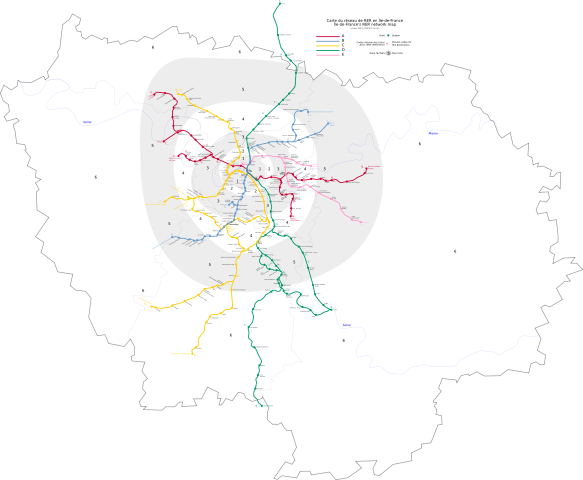
This is an Île de France's RER network map, in scalable vector graphics format, including fare zones, rivers and mission codes. |
|||||
|---|---|---|---|---|---|---|
| Source |
Données géographiques du domaine public |
|||||
| Date |
July 9th, 2006 |
|||||
| Author |
Benoit Mortgat ( User page/Page utilisateur) |
|||||
| Permission ( Reusing this image) |
|

File history
Click on a date/time to view the file as it appeared at that time.
| Date/Time | Dimensions | User | Comment | |
|---|---|---|---|---|
| current | 16:59, 2 July 2007 | 3,540×2,913 (689 KB) | Gonioul | (1er juillet 2007: zones 7&8 -> 6, viry-chatillon zone 5->4) |
| 04:38, 7 March 2007 | 3,540×2,913 (696 KB) | Gonioul | (-Argenteuil / +Pont du Garigliano) | |
| 09:00, 9 July 2006 | 3,540×2,913 (705 KB) | Pabix | ('''You can zoom! Use a software to edit .SVG files, like [http://www.inkscape.org Inkscape]''' '''Vous pouvez agrandir ! Utilisez un logiciel tel [http://www.inkscape.org Inkscape] pour éditer les fichiers .svg''' PNG version available here: [[:Image:P) | |
| 22:17, 26 June 2006 | 744×1,052 (705 KB) | Pabix | ('''You can zoom! Use a software to edit .SVG files, like [http://www.inkscape.org Inkscape]''' '''Vous pouvez agrandir ! Utilisez un logiciel tel [http://www.inkscape.org Inkscape] pour éditer les fichiers .svg''' PNG version available here: [[:Image:P) | |
| 14:24, 23 June 2006 | 744×1,052 (706 KB) | Pabix | ('''You can zoom! Use a software to edit .SVG files, like [http://www.inkscape.org Inkscape]''' '''Vous pouvez agrandir ! Utilisez un logiciel tel [http://www.inkscape.org Inkscape] pour éditer les fichiers .svg''' PNG version available here: [[:Image:P) | |
| 22:26, 19 June 2006 | 744×1,052 (706 KB) | Pabix | (== Description == This is an Île de France's RER network map, in scalable vector graphics format, including fare zones, rivers and mission codes. Ceci est une carte du réseau de RER en Île de France au format vectoriel, comprenant les zones tarifaires) | |
| 21:42, 19 June 2006 | 744×1,052 (705 KB) | Pabix | (This is an Île de France's RER network map, in scalable vector graphics format, including fare zones, rivers and mission codes. Ceci est une carte du réseau de RER en Île de France au format vectoriel, comprenant les zones tarifaires, fleuves et codes) |