Image:2004 Atlantic hurricane season map.png
From Wikipedia, the free encyclopedia
Size of this preview: 640 × 470 pixels
Full resolution (1,300 × 954 pixels, file size: 1.31 MB, MIME type: image/png)
| |
This is a file from the Wikimedia Commons. The description on its description page there is shown below. |
Summary
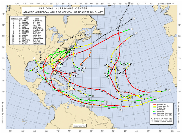
Season summary provided by NOAA of the 2004 Atlantic hurricane season.
From . For usage instructions and information about updating this image, see here.
 |
This map image should be recreated using vector graphics as an SVG file. This has several advantages; see Commons:Media for cleanup for more information. If an SVG form of this image is already available, please upload it. After uploading an SVG, replace this template with {{ vector version available|new image name.svg}}. |
|
العربية | Български | Català | Česky | Dansk | Deutsch | English | Esperanto | Español | Français | Galego | 한국어 | Italiano | Magyar | Lietuvių | Nederlands | 日本語 | Polski | Português | Română | Русский | Suomi | Svenska | Türkçe | Українська | 中文(繁體) | 中文(简体) | +/- |
|
Licensing
 |
This image is in the public domain because it contains materials that originally came from the U.S. National Oceanic and Atmospheric Administration, taken or made during the course of an employee's official duties. |
 |
File history
Click on a date/time to view the file as it appeared at that time.
| Date/Time | Dimensions | User | Comment | |
|---|---|---|---|---|
| current | 06:24, 23 October 2005 | 1,300×954 (1.31 MB) | Jdorje | ({{Atlantic hurricane season map|2004}}) |
File links
The following pages on Schools Wikipedia link to this image (list may be incomplete):