Image:Hurricane Danielle 16 aug 2004 1815Z.jpg
From Wikipedia, the free encyclopedia
Size of this preview: 480 × 480 pixels
Full resolution (898 × 898 pixels, file size: 267 KB, MIME type: image/jpeg)
| |
This is a file from the Wikimedia Commons. The description on its description page there is shown below. |
Summary
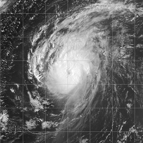
| Description |
This image of Hurricane Danielle was captured by the GOES-12 satellite on August 16, 2004 at 1815 UTC. Danielle was located in the Atlantic Ocean with peak winds of 110 mph and a minimum pressure of 964 mb. |
|||
|---|---|---|---|---|
| Source |
http://www.nrlmry.navy.mil/tc_pages/tc_home.html |
|||
| Date |
2004-08-16 |
|||
| Author |
Naval Research Laboratory |
|||
| Permission ( Reusing this image) |
|


File history
Click on a date/time to view the file as it appeared at that time.
| Date/Time | Dimensions | User | Comment | |
|---|---|---|---|---|
| current | 18:08, 3 November 2006 | 898×898 (267 KB) | Good kitty | (== Summary == {{Information |Description=This image of Hurricane Danielle was captured by the GOES-12 satellite on August 16, 2004 at 1815 UTC. Danielle was located in the Atlantic Ocean with peak winds of 110 mph and a minimum pressure of 964 mb. |Source) |
File links
The following pages on Schools Wikipedia link to this image (list may be incomplete):