Image:Hurricane Gaston 2004.jpg
From Wikipedia, the free encyclopedia
Size of this preview: 586 × 479 pixels
Full resolution (4,400 × 3,600 pixels, file size: 3.2 MB, MIME type: image/jpeg)
| |
This is a file from the Wikimedia Commons. The description on its description page there is shown below. |
Summary
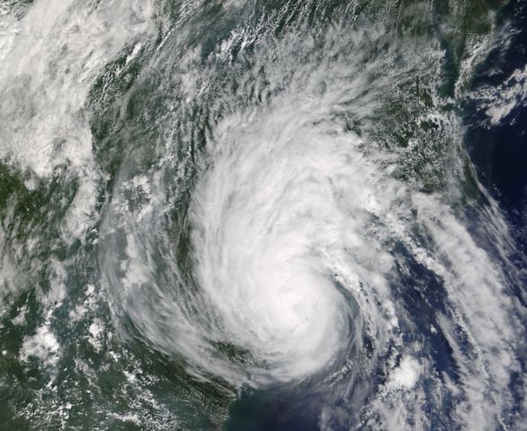
| Description |
The MODIS instrument aboard NASA's Terra satellite captured this true-colour image of Tropical Storm Gaston just after it came ashore near McClellanville, South Carolina. At the time this image was taken, Gaston had maximum sustained winds near 60 mph and was dumping copious amounts rain in North and South Carolina. The MODIS Rapid Response System provides this image at additional resolutions and formats. |
|||
|---|---|---|---|---|
| Source |
http://earthobservatory.nasa.gov/NaturalHazards/natural_hazards_v2.php3?img_id=12377 |
|||
| Date |
2004-08-29 |
|||
| Author |
NASA image courtesy Jeff Schmaltz, MODIS Land Rapid Response Team at NASA GSFC. |
|||
| Permission ( Reusing this image) |
|


File history
Click on a date/time to view the file as it appeared at that time.
| Date/Time | Dimensions | User | Comment | |
|---|---|---|---|---|
| current | 21:13, 17 August 2006 | 4,400×3,600 (3.2 MB) | Good kitty | (== Summary == {{Information |Description=The MODIS instrument aboard NASA's Terra satellite captured this true-colour image of Tropical Storm Gaston just after it came ashore near McClellanville, South Carolina. At the time this image was taken, Gaston had) |
File links
The following pages on Schools Wikipedia link to this image (list may be incomplete):