Image:Topographic map of Svalbard.svg

From Wikipedia, the free encyclopedia

Topographic_map_of_Svalbard.svg‎ (SVG file, nominally 2,400 × 2,898 pixels, file size: 4.47 MB)

Wikimedia Commons logo This is a file from the Wikimedia Commons. The description on its description page there is shown below.
Commons is a freely licensed media file repository. You can help.

Summary

This vector image was created with Inkscape.
Description
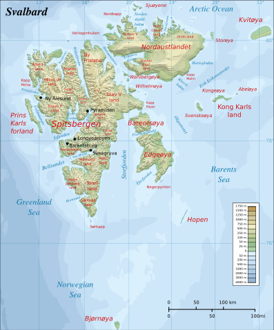
English: Topographic map of Svalbard.
Suomi: Huippuvuorten topografinen kartta.
Source

Self-made in Inkscape by Mysid.
Coastline from a CIA map ( Image:Sv-map.png) and topographic data (see below).
Locations of place names based on the Russian-Norwegian Directory ( http://www.russia.no/regional/svalbard/).
Topographic data from MGG-GLOBE ( http://www.ngdc.noaa.gov/mgg/topo/gltiles.html), automatically traced.
Bathymetric data from MGG-IBCAO ( http://www.ngdc.noaa.gov/mgg/bathymetry/arctic/arctic.html), manually traced into orthogonal projection.
Big file size is because of the relief shading, which is an embedded PNG bitmap.
Colors and overall look based on maps by User:Bamse.

Date

February 14, 2008

Author

Mysid

Permission
( Reusing this image)

see below


Licensing

I, the copyright holder of this work, hereby publish it under the following licenses:
GNU head Permission is granted to copy, distribute and/or modify this document under the terms of the GNU Free Documentation license, Version 1.2 or any later version published by the Free Software Foundation; with no Invariant Sections, no Front-Cover Texts, and no Back-Cover Texts. A copy of the license is included in the section entitled " GNU Free Documentation license".

Aragonés | العربية | Asturianu | Беларуская (тарашкевіца) | Български | বাংলা | ইমার ঠার/বিষ্ণুপ্রিয়া মণিপুরী | Brezhoneg | Bosanski | Català | Cebuano | Česky | Dansk | Deutsch | Ελληνικά | English | Esperanto | Español | Eesti | Euskara | فارسی | Suomi | Français | Gaeilge | Galego | עברית | Hrvatski | Magyar | Bahasa Indonesia | Ido | Íslenska | Italiano | 日本語 | ქართული | ភាសាខ្មែរ | 한국어 | Kurdî / كوردی | Latina | Lëtzebuergesch | Lietuvių | Bahasa Melayu | Nnapulitano | Nederlands | ‪Norsk (nynorsk)‬ | ‪Norsk (bokmål)‬ | Occitan | Polski | Português | Română | Русский | Slovenčina | Slovenščina | Shqip | Српски / Srpski | Svenska | తెలుగు | ไทย | Tagalog | Türkçe | Українська | اردو | Tiếng Việt | Volapük | Yorùbá | ‪中文(简体)‬ | ‪中文(繁體)‬ | +/-

Some rights reserved
Creative Commons Attribution icon Creative Commons Share Alike icon
This file is licensed under the Creative Commons Attribution ShareAlike license versions 3.0, 2.5, 2.0, and 1.0

Български | Català | Česky | Dansk | Deutsch | Ελληνικά | English | Español | Euskara | Estremeñu | Français | עברית | Italiano | 日本語 | 한국어 | Lietuvių | Nederlands | ‪Norsk (bokmål)‬  | Occitan | Polski | Piemontèis | Português | Русский | 中文 | +/-

You may select the license of your choice.

File history

Click on a date/time to view the file as it appeared at that time.

Date/Time Dimensions User Comment
current 18:27, 25 February 2008 2,400×2,898 (4.47 MB) Mysid (shading)
19:29, 16 February 2008 2,400×2,898 (1.29 MB) Mysid (ok, works not.)
19:27, 16 February 2008 2,400×2,898 (1.61 MB) Mysid (retry)
19:20, 16 February 2008 2,400×2,898 (1.29 MB) Mysid (embedded relief shading bitmap)
13:05, 14 February 2008 2,400×2,898 (1.29 MB) Mysid ({{Inkscape}} {{Information |Description={{en|Topographic map of Svalbard.}} {{fi| Huippuvuorten topografinen kartta.}} |Source=Self-made in Inkscape by Mysid.<br/> Coastline from a CIA map ([[:Image:Sv-m)
The following pages on Schools Wikipedia link to this image (list may be incomplete):
This Wikipedia DVD Selection was sponsored by a UK Children's Charity, SOS Children UK , and is mainly selected from the English Wikipedia with only minor checks and changes (see www.wikipedia.org for details of authors and sources). See also our Disclaimer.