Image:Bjornoya Location Map-en.svg

From Wikipedia, the free encyclopedia

Bjornoya_Location_Map-en.svg‎ (SVG file, nominally 1,010 × 1,267 pixels, file size: 242 KB)

Wikimedia Commons logo This is a file from the Wikimedia Commons. The description on its description page there is shown below.
Commons is a freely licensed media file repository. You can help.

Description

Description
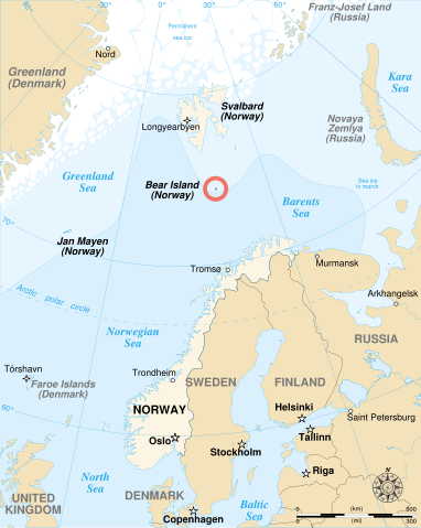
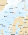
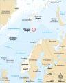
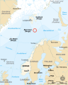
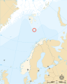
English:
English map showing the location of Bjørnøya (Bear Island in English), an island between Norway and Svalbard.
Français :
Carte en anglais montrant la localisation de l'île aux Ours (Bjørnøya en Norvégien), située entre la Norvège et l'archipel de Svalbard.
Source

Own work, from Image:Bjornoya map.png, Image:Arctic big.svg and Image:Barents 1942.svg.

Date

2007-11-02

Author

Sémhur · · ·

Permission
( Reusing this image)

See below.

Other versions


Camera location

74.45° N, 19° E

See this image at its location on Google Maps

This location on: Live Maps - Trails.com - TerraServer-USA


Atelier graphique
Remarque
English: This map was made or improved by the Wikigraphists of the Atelier graphique. You can propose maps or images to clean up and improve as well.
Esperanto: Ĉi tiu mapo estis kreita aŭ plibonigita de la Vikigrafistoj el la Grafika laborgrupo. Vi ankaŭ povas tie proponi mapojn aŭ bildojn plibonigendajn.
Español: Este mapa ha sido confeccionado o mejorado por los Wikígrafos del Taller gráfico. Puedes proponer la mejora de cualquier imagen a través de la página de Peticiones.
Français : Cette carte a été créée ou améliorée par les Wikigraphistes de l' Atelier graphique. Vous pouvez également y proposer des cartes ou des images à améliorer.
Türkçe: Bu harita Atelier graphique'ten Wikigraphistes'ler tarafından yapıldı veya geliştirildi. Siz de haritalar veya resimleri temizlemek veya geliştirmek için teklif edebilirsiniz.
This SVG file uses embedded text that can be easily translated into your language. Learn more.

For SVG images, you can use this page to translate it into your language.


العربية | Català | Dansk | Deutsch | English | Esperanto | Español | Français | Galego | Italiano | 日本語 | Lietuvių | Magyar | Nederlands | Polski | Português | Русский | Svenska | Українська | +/-

This vector image was created with Inkscape.

Licensing

I, the copyright holder of this work, hereby publish it under the following licenses:
GNU head Permission is granted to copy, distribute and/or modify this document under the terms of the GNU Free Documentation license, Version 1.2 or any later version published by the Free Software Foundation; with no Invariant Sections, no Front-Cover Texts, and no Back-Cover Texts. A copy of the license is included in the section entitled " GNU Free Documentation license".

Aragonés | العربية | Asturianu | Беларуская (тарашкевіца) | Български | বাংলা | ইমার ঠার/বিষ্ণুপ্রিয়া মণিপুরী | Brezhoneg | Bosanski | Català | Cebuano | Česky | Dansk | Deutsch | Ελληνικά | English | Esperanto | Español | Eesti | Euskara | فارسی | Suomi | Français | Gaeilge | Galego | עברית | Hrvatski | Magyar | Bahasa Indonesia | Ido | Íslenska | Italiano | 日本語 | ქართული | ភាសាខ្មែរ | 한국어 | Kurdî / كوردی | Latina | Lëtzebuergesch | Lietuvių | Bahasa Melayu | Nnapulitano | Nederlands | ‪Norsk (nynorsk)‬ | ‪Norsk (bokmål)‬ | Occitan | Polski | Português | Română | Русский | Slovenčina | Slovenščina | Shqip | Српски / Srpski | Svenska | తెలుగు | ไทย | Tagalog | Türkçe | Українська | اردو | Tiếng Việt | Volapük | Yorùbá | ‪中文(简体)‬ | ‪中文(繁體)‬ | +/-

Some rights reserved
Creative Commons Attribution icon Creative Commons Share Alike icon
This file is licensed under the Creative Commons Attribution ShareAlike license versions 3.0, 2.5, 2.0, and 1.0

Български | Català | Česky | Dansk | Deutsch | Ελληνικά | English | Español | Euskara | Estremeñu | Français | עברית | Italiano | 日本語 | 한국어 | Lietuvių | Nederlands | ‪Norsk (bokmål)‬  | Occitan | Polski | Piemontèis | Português | Русский | 中文 | +/-

You may select the license of your choice.

File history

Click on a date/time to view the file as it appeared at that time.

Date/Time Dimensions User Comment
current 14:00, 2 November 2007 1,010×1,267 (242 KB) Sémhur ({{Information| Description= {{en}}English map showing the location of Bjørnøya (''Bear Island'' in English), an island between Norway and Svalbard. {{fr}}Carte en anglais montrant la localisation de l'île aux Ours (''Bjørnøya'' en Norvégien), situ\xC3)
The following pages on Schools Wikipedia link to this image (list may be incomplete):
The 2008 Wikipedia for Schools is sponsored by SOS Children , and consists of a hand selection from the English Wikipedia articles with only minor deletions (see www.wikipedia.org for details of authors and sources). See also our Disclaimer.