Image:Space Radar Image of Taiwan.jpg
From Wikipedia, the free encyclopedia
No higher resolution available.
Space_Radar_Image_of_Taiwan.jpg (600 × 395 pixels, file size: 50 KB, MIME type: image/jpeg)
| |
This is a file from the Wikimedia Commons. The description on its description page there is shown below. |
| Description |
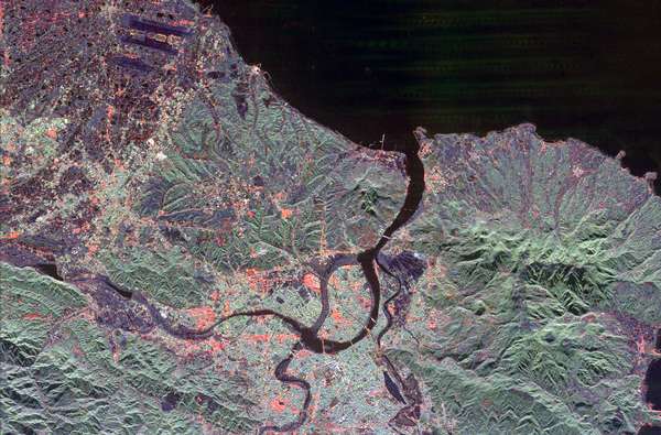
The northern end of the island country of Taiwan, including the capital city of Taipei, is shown in this spaceborne radar image. Taipei is the bright blue and red area in the lower centre of the image. A portion of the city sits on an island surrounded by the Keelung and Freshwater Rivers. The main channel of the Freshwater River is to the right of the island and appears dark in the image. The channel to the left of the island is no longer active and appears lighter. Rugged, heavily vegetated mountains surround the city and are shown in green. The runways of the Chiang Kai Shek International Airport are seen as dark parallel strips in the upper left of the image. This image was acquired by Spaceborne Imaging Radar-C/X-Band Synthetic Aperture Radar (SIR-C/X-SAR) onboard the space shuttle Endeavour on April 10, 1994. The image is 50 kilometers by 33 kilometers (31 miles by 20 miles) and is centered at 25.1 degrees north latitude, 121.5 degrees east longitude. North is toward the upper right. The colors are assigned to different radar frequencies and polarizations of the radar as follows: red is L-band, horizontally transmitted and received; green is L-band, horizontally transmitted, vertically received; and blue is C-band, horizontally transmitted, vertically received. SIR-C/X-SAR, a joint mission of the German, Italian and United States space agencies, is part of NASA's Mission to Planet Earth program.
|
|---|---|
| Source |
http://visibleearth.nasa.gov/view_rec.php?id=511 |
| Date |
April 10, 1994 |
| Author |
NASA JPL |
| Permission ( Reusing this image) |
see below
|
Licensing
 |
This file is in the public domain because it was created by NASA. NASA copyright policy states that "NASA material is not protected by copyright unless noted". ( NASA copyright policy page or JPL Image Use Policy). Deutsch | English | Español | Français | Galego | Nederlands | Português | Русский | 中文(简体) | 中文(繁體) | +/- |
|
 |
Warnings:
|
File history
Click on a date/time to view the file as it appeared at that time.
| Date/Time | Dimensions | User | Comment | |
|---|---|---|---|---|
| current | 02:16, 15 November 2004 | 600×395 (50 KB) | Wdshu | ({{PD-USGov-NASA}}) |