From Wikipedia, the free encyclopedia
 No higher resolution available.PostVeniceLG.jpg
 (600 × 399 pixels, file size: 48 KB, MIME type: image/jpeg)
 |
This is a file from the Wikimedia Commons. The description on its description page there is shown below.Commons is a freely licensed media file repository. You can help.
|
| Description |
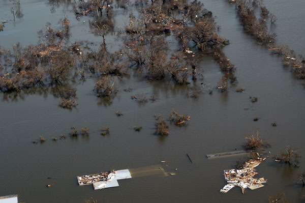
Flooding in Venice, Louisiana after Hurricane Katrina. Part of Venice, LA, on August 30, 2005. The southernmost permanently inhabited area on the Louisiana coast, Venice is located within a ring levee on the Mississippi River. The levee was ineffective during Hurricane Katrina. The entire town was flooded, oil-field vessels and barges were strewn haphazardly, and huge deposits of wrack were left on both sides of the ring levee on the west side of town. |
| Source |
http://soundwaves.usgs.gov/2005/09/ |
| Date |
30 August 2005 |
| Author |
User Storm05 on en.wikipedia |
Permission
( Reusing this image) |
 |
This image is in the public domain because it contains materials that originally came from the United States Geological Survey, an agency of the United States Department of Interior. For more information, see the official USGS copyright policy |
|
|
| Other versions |
Originally from en.wikipedia; description page is (was) here * 19:11, 27 April 2006 [[:en:User:Storm05|Storm05]] 600×399 (49,436 bytes) <span class="comment">(Flooding in Venice, Louisiana http://soundwaves.usgs.gov/2005/09/ {{PD-USGov-Interior-USGS}} )</span> |
File history
Click on a date/time to view the file as it appeared at that time.
|
|
Date/Time |
Dimensions |
User |
Comment |
| current |
12:48, 14 August 2006 |
600×399 (48 KB) |
Nilfanion |
|
File links
The following pages on Schools Wikipedia link to this image (list may be incomplete):

