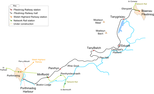
Image:FfestiniogRailwayMap.png
From Wikipedia, the free encyclopedia

Size of this preview: 640 × 391 pixels
Full resolution (2,585 × 1,580 pixels, file size: 227 KB, MIME type: image/png)
File history
Click on a date/time to view the file as it appeared at that time.
| Date/Time | Dimensions | User | Comment | |
|---|---|---|---|---|
| current | 22:06, 7 December 2006 | 2,585×1,580 (227 KB) | Gwernol | ({{Information |Description=Ffestiniog Railway route map, 2006 |Source=own work |Date=December 7, 2006 |Author=Dan Crow |Permission=GFDL, own work |other_versions= }} ) |
| 20:42, 4 December 2006 | 2,557×1,609 (225 KB) | Gwernol | ({{Information |Description=Route of the Ffestiniog Railway, 2006 |Source=Own work |Date=December 4, 2006 |Author=Dan Crow |Permission=GFDL< own work |other_versions= }}) | |
| 18:11, 4 December 2006 | 2,518×1,609 (196 KB) | Gwernol | ({{Information |Description=Ffestiniog Railway route map, 2006 |Source=own work |Date=December 4, 2006 |Author=Dan Crow |Permission=GFDL, own work |other_versions= }}) | |
| 20:59, 2 December 2006 | 2,427×1,377 (163 KB) | Gwernol | ({{Information |Description=Map of the FFestiniog Railway, 2006 |Date=December 2, 2006 |Author=Dan Crow }}) | |
| 20:57, 2 December 2006 | 2,428×1,371 (132 KB) | Gwernol | ({{Information |Description=Map of the Ffestiniog Railway, 2006 |Date=December 2, 2006 |Author=Dan Crow |Permission=GFDL }}) | |
| 17:55, 15 September 2006 | 2,428×1,371 (132 KB) | Gwernol | (Map of the Ffestiniog Railway, 2006 Author: Dan Crow) |
File links
The following pages on Schools Wikipedia link to this image (list may be incomplete):
Categories: Railway maps of the United Kingdom


