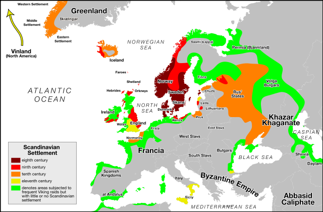
Image:Viking Expansion.svg
From Wikipedia, the free encyclopedia

Viking_Expansion.svg (SVG file, nominally 793 × 521 pixels, file size: 1.9 MB)
File history
Click on a date/time to view the file as it appeared at that time.
| Date/Time | Dimensions | User | Comment | |
|---|---|---|---|---|
| current | 20:38, 24 June 2007 | 793×521 (1.9 MB) | Max Naylor | (== Summary == {{Information |Description=An SVG version of this image. Created with Adobe Illustrator CS3. Based on the blank Europe map available on the Commons. The enclosed legend is as follows: {{legend|#800000|eighth c) |
| 20:25, 24 June 2007 | 793×521 (1.25 MB) | Max Naylor | (== Summary == {{Information |Description=An SVG version of this image. Created with Adobe Illustrator CS3. Based on the blank Europe map available on the Commons. The enclosed legend is as follows: {{legend|#800000|eighth c) | |
| 20:20, 24 June 2007 | 793×521 (1.26 MB) | Max Naylor | (== Summary == {{Information |Description=An SVG version of this image. Created with Adobe Illustrator CS3. Based on the blank Europe map available on the Commons. The enclosed legend is as follows: {{legend|#800000|eighth c) | |
| 20:18, 24 June 2007 | 793×521 (1.26 MB) | Max Naylor | (== Summary == {{Information |Description=An SVG version of this image. Created with Adobe Illustrator CS3. Based on the blank Europe map available on the Commons. The enclosed legend is as follows: {{legend|#800000|eighth c) | |
| 20:16, 24 June 2007 | 2,443×682 (1.26 MB) | Max Naylor | ({{Information |Description=An SVG version of this image. Created with Adobe Illustrator CS3. Based on the blank Europe map available on the Commons. The enclosed legend is as follows: {{legend|#800000|eighth centuries}} {{l) |
File links
The following pages on Schools Wikipedia link to this image (list may be incomplete):
