Image:Sunda strait map v3.png
From Wikipedia, the free encyclopedia
Size of this preview: 391 × 480 pixels
Full resolution (489 × 600 pixels, file size: 310 KB, MIME type: image/png)
| |
This is a file from the Wikimedia Commons. The description on its description page there is shown below. |
Summary
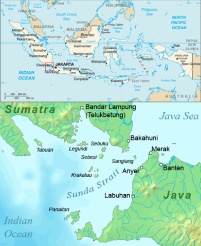
| Description |
English: Map of the Sunda Strait, Indonesia.
|
|||
|---|---|---|---|---|
| Source |
Combination of CIA World Factbook map and Demis Map Server ( http://www2.demis.nl/mapserver/mapper.asp) data with additional annotations and modifications by self. |
|||
| Date |
26 August 2006 |
|||
| Author |
ChrisO |
|||
| Permission ( Reusing this image) |
|


File history
Click on a date/time to view the file as it appeared at that time.
| Date/Time | Dimensions | User | Comment | |
|---|---|---|---|---|
| current | 10:39, 2 December 2006 | 489×600 (310 KB) | Triquetra | (Caricato da en.wiki) |
File links
The following pages on Schools Wikipedia link to this image (list may be incomplete):