Image:Plan-1966.jpg
From Wikipedia, the free encyclopedia
Size of this preview: 640 × 156 pixels
Full resolution (1,931 × 472 pixels, file size: 200 KB, MIME type: image/jpeg)
| |
This is a file from the Wikimedia Commons. The description on its description page there is shown below. |
Summary
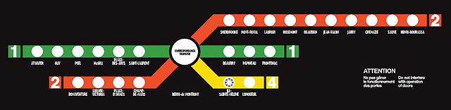
| Description |
1966 Montreal Metro onboard network map |
|---|---|
| Source |
Bureau des Transports de Montréal (BTM) |
| Date |
1966 |
| Author |
Bureau des Transports de Montréal (BTM) |
| Permission ( Reusing this image) |
Freely distributed at the time by this now defunct city public organisation
|
Licensing
 |
The copyright holder of this file allows anyone to use it for any purpose, provided that the copyright holder is properly attributed. Redistribution, derivative work, commercial use, and all other use is permitted. Aragonés | العربية | Български | Català | Dansk | Deutsch | Ελληνικά | English | Español | Español | Français | עברית | Magyar | Galego | Italiano | 日本語 | 한국어 | Kurdî / كوردی | Latviešu | Nederlands | Norsk (bokmål) | Polski | Português | Svenska | Türkçe | Русский | 中文(简体) | 中文(繁體) | +/- |
File history
Click on a date/time to view the file as it appeared at that time.
| Date/Time | Dimensions | User | Comment | |
|---|---|---|---|---|
| current | 00:09, 19 April 2008 | 1,931×472 (200 KB) | Noname2 | (Higher quality version from http://www.stm.info/info/infostm/2004/040310.pdf) |
| 05:38, 14 September 2006 | 788×200 (49 KB) | Mekmtl | ({{Information |Description=1966 Montreal Metro onboard network map |Source=Bureau des Transports de Montréal (BTM) |Date=1966 |Author=Bureau des Transports de Montréal (BTM) |Permission=Freely distributed at the time by this now defunct city public orga) |
File links
The following pages on Schools Wikipedia link to this image (list may be incomplete):