Image:Mtl-metro-map.svg
From Wikipedia, the free encyclopedia
Mtl-metro-map.svg (SVG file, nominally 500 × 499 pixels, file size: 592 KB)
| |
This is a file from the Wikimedia Commons. The description on its description page there is shown below. |
| |
This image was previously a featured picture, but community consensus determined that it no longer meets our featured picture criteria. If you have a high quality image that you believe meets the criteria, be sure to upload it, using the proper free license tag, then add it to a relevant article and nominate it. |
| |
This image was selected as picture of the day on the English Wikipedia for August 18, 2004, and July 22, 2005. |
This is an SVG version of en:Image:Mtl-metro-map.png by Montrealais (which was released as GFDL) by grm_wnr, made with Inkscape.
Description of the original PNG version by Montrealais
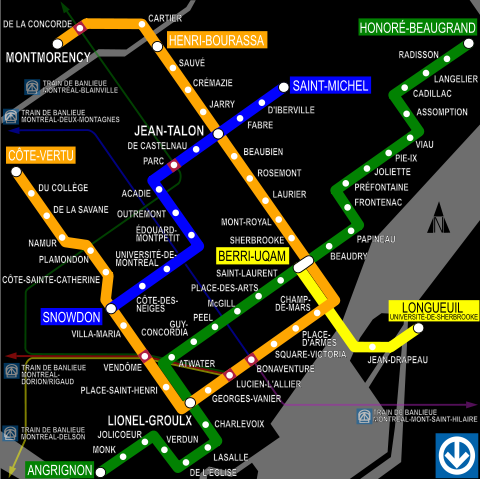
en:Montreal metro map.
A new version of one that will soon be found on my personal website, http://www.metrodemontreal.com/ .
I am the creator and this version is released under the GNU FDL.
Neither it nor I are in any way affiliated with the Société de transport de Montréal.
 |
Permission is granted to copy, distribute and/or modify this document under the terms of the GNU Free Documentation license, Version 1.2 or any later version published by the Free Software Foundation; with no Invariant Sections, no Front-Cover Texts, and no Back-Cover Texts. A copy of the license is included in the section entitled " GNU Free Documentation license". Aragonés | العربية | Asturianu | Беларуская (тарашкевіца) | Български | বাংলা | ইমার ঠার/বিষ্ণুপ্রিয়া মণিপুরী | Brezhoneg | Bosanski | Català | Cebuano | Česky | Dansk | Deutsch | Ελληνικά | English | Esperanto | Español | Eesti | Euskara | فارسی | Suomi | Français | Gaeilge | Galego | עברית | Hrvatski | Magyar | Bahasa Indonesia | Ido | Íslenska | Italiano | 日本語 | ქართული | ភាសាខ្មែរ | 한국어 | Kurdî / كوردی | Latina | Lëtzebuergesch | Lietuvių | Bahasa Melayu | Nnapulitano | Nederlands | Norsk (nynorsk) | Norsk (bokmål) | Occitan | Polski | Português | Română | Русский | Slovenčina | Slovenščina | Shqip | Српски / Srpski | Svenska | తెలుగు | ไทย | Tagalog | Türkçe | Українська | اردو | Tiếng Việt | Volapük | Yorùbá | 中文(简体) | 中文(繁體) | +/- |
File history
Click on a date/time to view the file as it appeared at that time.
| Date/Time | Dimensions | User | Comment | |
|---|---|---|---|---|
| current | 04:09, 10 May 2007 | 500×499 (592 KB) | Sjschen | ({{Information |Description= Modified previous version for newest Montreal Metro extensions in the north. |Source=Self-made revision from version by User:Grm wnr |Date=May 10 |Author= User:Sjschen |Permission=GFDL }}) |
| 05:48, 17 April 2006 | 500×499 (593 KB) | Grm wnr | (Again with text as paths - the only way that works) | |
| 05:43, 17 April 2006 | 500×499 (147 KB) | Grm wnr | (Another attempt an an unified version) | |
| 05:34, 17 April 2006 | 500×499 (139 KB) | Grm wnr | (An attempt at an unified version) | |
| 04:15, 17 April 2006 | 500×499 (593 KB) | Grm wnr | (This is the plain SVG version, with the text converted to paths (because the SVG => PNG renderer screws it up otherwise, as can be plainly seen in the previous version)) | |
| 04:12, 17 April 2006 | 500×499 (158 KB) | Grm wnr | (This is the Inkscape SVG file with text-as-text, in case someone wants to modify it) |