Image:GW-region.svg
From Wikipedia, the free encyclopedia

GW-region.svg (SVG file, nominally 660 × 400 pixels, file size: 68 KB)
 |
This is a candidate to be copied to the Wikimedia Commons. Appropriately licensed media are more accessible to other Wikimedia projects if placed on Commons. Any user may perform this move - please see Moving images to the Commons for more information. Please remove this tag after this image has been copied to Commons. Copy to Commons via CommonsHelper |
| |
This vector image was created with Inkscape. |
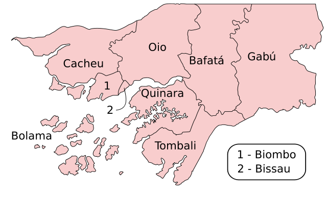
Map of the Regions of Guinea-Bissau; originally created with the GIMP by User:Acntx; converted to SVG by User:DTR. The original file was Image:GW-regions.png.
 |
Permission is granted to copy, distribute and/or modify this document under the terms of the GNU Free Documentation License, Version 1.2 or any later version published by the Free Software Foundation; with no Invariant Sections, no Front-Cover Texts, and no Back-Cover Texts. Subject to disclaimers. |
File history
Click on a date/time to view the file as it appeared at that time.
| Date/Time | Dimensions | User | Comment | |
|---|---|---|---|---|
| current | 19:39, 19 June 2007 | 660×400 (68 KB) | DTR ( Talk | contribs) | (<!-- This version of the file will hopefully render the font correctly -->Map of the Regions of Guinea-Bissau; originally created with the GIMP by User:Acntx; converted to SVG by User:DTR {{Inkscape}} {{GFDL-with-disclaimers}} ) |
| revert | 19:26, 19 June 2007 | 660×400 (66 KB) | DTR ( Talk | contribs) | (Map of the Regions of Guinea-Bissau; originally created with the GIMP by User:Acntx; converted to SVG by User:DTR {{Inkscape}} {{GFDL-with-disclaimers}} ) |
See the setup instructions for more information.
File links
The following pages on Schools Wikipedia link to this image (list may be incomplete):
Categories: Copy to Wikimedia Commons | Created with Inkscape