Image:Map baker glaciers.gif
From Wikipedia, the free encyclopedia
Size of this preview: 380 × 479 pixels
Full resolution (415 × 523 pixels, file size: 12 KB, MIME type: image/gif)
Summary
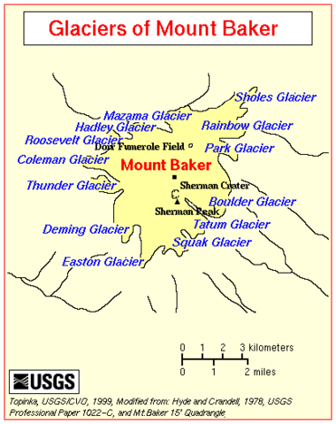
A map of the glaciers on Mount Baker in the Cascades Volcanic Arc in Washington. Source is Picture by Hyde and Crandell, 1978, USGS
Licensing:
 |
This image is a work of a United States Geological Survey employee, taken or made during the course of the person's official duties. As a work of the United States Government, the image is in the public domain. For more information, see the USGS copyright policy. See Wikipedia:Public domain and Wikipedia:Copyrights for more details. | |
File history
Click on a date/time to view the file as it appeared at that time.
| Date/Time | Dimensions | User | Comment | |
|---|---|---|---|---|
| current | 19:22, 9 May 2008 | 415×523 (12 KB) | Meldshal42 ( Talk | contribs) | (A map of the glaciers on Mount Baker in the Cascades Volcanic Arc in Washington. Source is [http://vulcan.wr.usgs.gov/Volcanoes/Baker/Maps/map_baker_glaciers.html] Picture by Hyde and Crandell, 1978, USGS) |
See the setup instructions for more information.
File links
The following pages on Schools Wikipedia link to this image (list may be incomplete):
Categories: USGS images