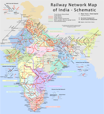
Image:Railway network schematic map.png
From Wikipedia, the free encyclopedia

Size of this preview: 438 × 480 pixels
Full resolution (2,282 × 2,500 pixels, file size: 928 KB, MIME type: image/png)
File history
Click on a date/time to view the file as it appeared at that time.
| Date/Time | Dimensions | User | Comment | |
|---|---|---|---|---|
| current | 18:16, 3 October 2006 | 2,282×2,500 (928 KB) | ProhibitOnions | (Corrected spelling of "gauge"; vector version needs correcting, too.) |
| 14:10, 16 April 2006 | 2,282×2,500 (526 KB) | PlaneMad | (minor corrections, added travel time) | |
| 16:54, 2 April 2006 | 2,303×2,500 (465 KB) | PlaneMad | (oops, uploaded wrong version) | |
| 16:49, 2 April 2006 | 2,303×2,500 (419 KB) | PlaneMad | (Done finally!!!) | |
| 18:10, 1 April 2006 | 2,303×2,500 (419 KB) | PlaneMad | ||
| 18:00, 31 March 2006 | 2,303×2,500 (378 KB) | PlaneMad | ||
| 16:18, 26 March 2006 | 2,303×2,500 (265 KB) | PlaneMad | (more labels added) | |
| 07:05, 26 March 2006 | 2,303×2,500 (219 KB) | PlaneMad | (A schematic map of the complicated Indian Railway network. ==Author== w:user:planemad ==Comments and Suggestions== Please leave your suggestions or errors noted in the map here. Category:Maps of India Category:Wikiproject Indian Maps) |
File links
The following pages on Schools Wikipedia link to this image (list may be incomplete):

