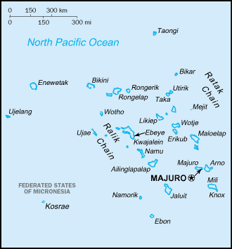
Image:Marshall islands-map.png
From Wikipedia, the free encyclopedia

No higher resolution available.
Marshall_islands-map.png (330 × 355 pixels, file size: 7 KB, MIME type: image/png)
File history
Click on a date/time to view the file as it appeared at that time.
| Date/Time | Dimensions | User | Comment | |
|---|---|---|---|---|
| current | 13:45, 29 September 2006 | 330×355 (7 KB) | Loveless | (This image was copied from wikipedia:fr. The original description was: ;source: fr:CIA World Factbook ;copyright: domaine public {{DomainePublic}} {| border="1" ! date/time || username || resolution || size || edit summary |---- | |}) |
File links
The following pages on Schools Wikipedia link to this image (list may be incomplete):

