Image:SeattleI5Skyline.jpg

From Wikipedia, the free encyclopedia
Wikimedia Commons logo This is a file from the Wikimedia Commons. The description on its description page there is shown below.
Commons is a freely licensed media file repository. You can help.

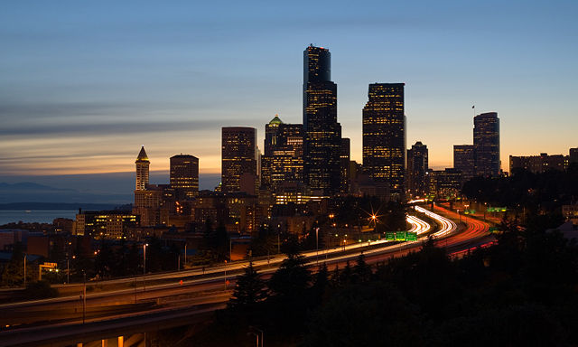
The skyline of Seattle, Washington at dusk, viewed from the south. The Columbia Centre (middle) is the second tallest building on the west coast of the United States, and the twelfth tallest in the United States. Smith Tower (left), completed 1914, was at one time the fourth tallest building in the world. The highway in the foreground is Interstate 5.

POTY
Featured picture
This file was a candidate on Picture of the Year 2007.
This is a featured picture on Wikimedia Commons: it is considered one of our finest images.
This is a featured picture on English Wikipedia and is considered one of the finest images.
This is a featured picture on Turkish Wikipedia and is considered one of the finest images.
If you have an image of similar quality that can be published under a suitable copyright license, be sure to upload it, tag it, and nominate it.
Wikimedia Commons
QI seal
Quality image

This image has been assessed using the Quality image guidelines and is considered a Quality image.

Picture of the day This image was selected as a picture of the day for August 29, 2007. It was captioned as followed:
English: The skyline of Seattle, Washington at dusk.

العربية: منظر عام وقت الغروب لمدينة سياتل و الموجودة في ولاية واشنطن على الساحل الغربي للولايات المتحدة الأمريكية
Asturianu: Seattle, Washington
Беларуская: Сілуэт горада Сіэтл ( ЗША) на змярканні.
Česky: Večerní silueta města Seattle, USA
Deutsch: Die Skyline von Seattle im Bundesstaat Washington, bei Dämmerung.
English: The skyline of Seattle, Washington at dusk.
Euskara: Seattle, Washington
Galego: Seattle, Washington
Magyar: Seattle-i szürkület
Íslenska: Útlínur miðborgar Seattle í ljósaskiptunum.
Italiano: La skyline di Seattle al tramonto.
日本語: アメリカ、ワシントン州 シアトルの夕暮れ
Nederlands: De skyline van de Amerikaanse stad Seattle in het schemerdonker
Polski: Panorama centrum Seattle, stan Washington, USA
Português: A linha do horizonte da cidade de Seattle, em Washington, ao anoitecer.
Русский: Панорама Сиэтла в сумерках
Svenska: Seattles skyline i skymningen.
Українська: Силует міста Сіетл (США) в сутінках.
‪中文(简体)‬: 美国 西雅图黄昏景色
‪中文(繁體)‬: 美國 西雅圖的黃昏景色

Desktop wallpaper icon
This featured picture is fairly large and has an aspect ratio of approximately 8:5, 16:10, or 16:9, making it suitable as a widescreen computer wallpaper.

See the gallery of such images, or the gallery of non-widescreen images.

Description
English: The skyline of Seattle, Washington at dusk. Interstate 5 is the freeway that cuts through downtown and Puget Sound is visible to the left.
Français : Le quartier d'affaire de Seattle (État de Washington, USA) au coucher du soleil. Le quartier est traversé par l'Interstate 5, qui est ici une autoroute. Sur la gauche de l'image, on aperçoit Puget Sound.
Русский: Вид г. Сиэтла (штат Вашингтон, США) в сумерках. Шоссе "Интерстэйт 5" проходит через центр города, слева виден залив Пьюджет-Саунд.

For more translations SEE BELOW

Source

self-made

Date

6/18/06

Author

Cacophony

Permission
( Reusing this image)
I, Cacophony, the copyright holder of this work, has published or hereby publishes it under the following licenses:
GNU head Permission is granted to copy, distribute and/or modify this document under the terms of the GNU Free Documentation license, Version 1.2 or any later version published by the Free Software Foundation; with no Invariant Sections, no Front-Cover Texts, and no Back-Cover Texts. A copy of the license is included in the section entitled " GNU Free Documentation license".

Aragonés | العربية | Asturianu | Беларуская (тарашкевіца) | Български | বাংলা | ইমার ঠার/বিষ্ণুপ্রিয়া মণিপুরী | Brezhoneg | Bosanski | Català | Cebuano | Česky | Dansk | Deutsch | Ελληνικά | English | Esperanto | Español | Eesti | Euskara | فارسی | Suomi | Français | Gaeilge | Galego | עברית | Hrvatski | Magyar | Bahasa Indonesia | Ido | Íslenska | Italiano | 日本語 | ქართული | ភាសាខ្មែរ | 한국어 | Kurdî / كوردی | Latina | Lëtzebuergesch | Lietuvių | Bahasa Melayu | Nnapulitano | Nederlands | ‪Norsk (nynorsk)‬ | ‪Norsk (bokmål)‬ | Occitan | Polski | Português | Română | Русский | Slovenčina | Slovenščina | Shqip | Српски / Srpski | Svenska | తెలుగు | ไทย | Tagalog | Türkçe | Українська | اردو | Tiếng Việt | Volapük | Yorùbá | ‪中文(简体)‬ | ‪中文(繁體)‬ | +/-

Some rights reserved
Creative Commons Attribution icon Creative Commons Share Alike icon
This file is licensed under the Creative Commons Attribution ShareAlike license versions 2.5, 2.0, and 1.0

العربية | Български | Català | Česky | Dansk | Deutsch | English | Español | Euskara | فارسی | Français | Galego | עברית | Italiano | 日本語 | 한국어 | Lietuvių | Nederlands | Polski | Português | Русский | Svenska | தமிழ் | తెలుగు | Türkçe | 中文 | 中文 | +/-

You may select the license of your choice.


Camera location

47°35′42″N, 122°19′02″W

This and other geocoded Commons images:
( Info)

File history

Click on a date/time to view the file as it appeared at that time.

Date/Time Dimensions User Comment
current 21:56, 1 July 2007 4,013×2,405 (3.08 MB) Cacophony (straightened)
05:14, 21 June 2007 4,026×2,249 (3.04 MB) Cacophony ({{Information |Description=The skyline of Seattle, Washington from the south at dusk. |Source=self-made |Date=6/18/06 |Author= Cacophony }} )
The following pages on Schools Wikipedia link to this image (list may be incomplete):
The 2008 Wikipedia for Schools was sponsored by a UK Children's Charity, SOS Children UK , and is a hand-chosen selection of article versions from the English Wikipedia edited only by deletion (see www.wikipedia.org for details of authors and sources). See also our Disclaimer.