Image:EasternSolomonsChart.jpg
From Wikipedia, the free encyclopedia
Size of this preview: 447 × 479 pixels
Full resolution (640 × 686 pixels, file size: 90 KB, MIME type: image/jpeg)
| |
This is a file from the Wikimedia Commons. The description on its description page there is shown below. |
| Description |
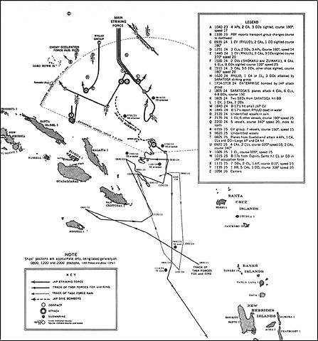
US Navy map of The Battle of the Eastern Solomons. Tracks of Allied (U.S.) forces are most likely fairly accurate. Tracks of Japanese forces are approximate and/or conjectured. The term "Jap" is used as shorthand for "Japanese" on the map. It's unknown whether this was used pejoratively in this publication or as an accepted abbreviation at that time. |
|---|---|
| Source |
US Government ( http://www.ibiblio.org/hyperwar/USN/USN-CN-ESols/index.html)The Battle of the Eastern Solomons, 23-25 August 1942, Navy Department Office of Naval Intelligence, Combat Narrative |
| Date |
Aug 24, 1942 |
| Author |
US Government |
| Permission ( Reusing this image) |
US Government/public domain
|
 |
This image is a work of a sailor or employee of the U.S. Navy, taken or made during the course of the person's official duties. As a work of the U.S. federal government, the image is in the public domain. |
 |
File history
Click on a date/time to view the file as it appeared at that time.
| Date/Time | Dimensions | User | Comment | |
|---|---|---|---|---|
| current | 16:12, 24 May 2006 | 640×686 (90 KB) | Cla68 | ({{Information| |Description= US Navy map of The Battle of the Eastern Solomons. This map may not be entirely accurate since it was published before World War II was over. |Source= US Government (http://www.ibiblio.org/hyperwar/USN/USN-CN-ESols/index.html) |
File links
The following pages on Schools Wikipedia link to this image (list may be incomplete):