Image:3850vc ex leg copy.jpg
From Wikipedia, the free encyclopedia
Size of this preview: 399 × 480 pixels
Full resolution (510 × 613 pixels, file size: 175 KB, MIME type: image/jpeg)
| |
This is a file from the Wikimedia Commons. The description on its description page there is shown below. |
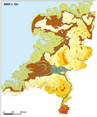
██ Strandwallen en duinen
██ Getijdengebied (zandwadden, slikken en kwelders)
██ Veenmoerassen en komgronden grote rivieren (inclusief verlande stroomgordels/crevassen)
██ Dal van de grote rivieren (niet overveend)
██ Rivierduinen (donken)
██ Open water (Zee, lagunes, rivieren)
██ Pleistoceen landschap (> -6 m t.o.v. NAP)
██ Pleistoceen landschap ( -6 m - 0 m)
██ Pleistoceen landschap ( 0 m - 10 m)
██ Pleistoceen landschap ( 10 m - 20 m)
██ Pleistoceen landschap ( 20 m - 50 m)
██ Pleistoceen landschap ( 50 m - 100 m)
██ Pleistoceen landschap ( 100 m - 200 m)
| Description |
Palaeography of the Netherlands 3850 BC |
|---|---|
| Source |
RACM & TNO. Developed for the Nationale Onderzoeksagenda Archeologie www.noaa.nl |
| Date |
12-7-2007 |
| Author |
RACM & TNO |
| Permission ( Reusing this image) |
Geachte heer Klein, U heeft gevraagd om het gebruik van de nieuwe paleogeografische kaarten van Nederland voor Wikipedia. Namens de RACM, rechthebende op de afbeeldingen, sta ik u toe deze afbeeldingen te gebruiken onder de GFDL licentie. Als bronvermelding bij de afbeelding moet vermeld worden: "RACM & TNO. Ontwikkeld voor de Nationale Onderzoeksagenda Archeologie www.noaa.nl" (of de Engelse vertaling hiervan) Ik hoop u hiermee voldoende te hebben geïnformeerd. Met vriendelijke groet, Margje Vermeulen
|
 |
Permission is granted to copy, distribute and/or modify this document under the terms of the GNU Free Documentation license, Version 1.2 or any later version published by the Free Software Foundation; with no Invariant Sections, no Front-Cover Texts, and no Back-Cover Texts. A copy of the license is included in the section entitled " GNU Free Documentation license". Aragonés | العربية | Asturianu | Беларуская (тарашкевіца) | Български | বাংলা | ইমার ঠার/বিষ্ণুপ্রিয়া মণিপুরী | Brezhoneg | Bosanski | Català | Cebuano | Česky | Dansk | Deutsch | Ελληνικά | English | Esperanto | Español | Eesti | Euskara | فارسی | Suomi | Français | Gaeilge | Galego | עברית | Hrvatski | Magyar | Bahasa Indonesia | Ido | Íslenska | Italiano | 日本語 | ქართული | ភាសាខ្មែរ | 한국어 | Kurdî / كوردی | Latina | Lëtzebuergesch | Lietuvių | Bahasa Melayu | Nnapulitano | Nederlands | Norsk (nynorsk) | Norsk (bokmål) | Occitan | Polski | Português | Română | Русский | Slovenčina | Slovenščina | Shqip | Српски / Srpski | Svenska | తెలుగు | ไทย | Tagalog | Türkçe | Українська | اردو | Tiếng Việt | Volapük | Yorùbá | 中文(简体) | 中文(繁體) | +/- |
File history
Click on a date/time to view the file as it appeared at that time.
| Date/Time | Dimensions | User | Comment | |
|---|---|---|---|---|
| current | 11:54, 12 July 2007 | 510×613 (175 KB) | BoH | ({{legend|#fff15d|Strandwallen en duinen}} {{legend|#d2d500|Getijdengebied (zandwadden, slikken en kwelders)}} {{legend|#b56c03|Veenmoerassen en komgronden grote rivieren (inclusief verlande stroomgordels/crevassen)}} {{legend|#a1aa95|Dal van de grote rivi) |
File links
Metadata
This file contains additional information, probably added from the digital camera or scanner used to create or digitize it. If the file has been modified from its original state, some details may not fully reflect the modified file.
| Width | 2165 |
|---|---|
| Height | 2599 |
| Compression scheme | Uncompressed |
| Pixel composition | 5 |
| Orientation | Normal |
| Number of components | 4 |
| Horizontal resolution | 72 dpi |
| Vertical resolution | 72 dpi |
| Data arrangement | chunky format |
| Software used | Adobe Photoshop CS2 Macintosh |
| File change date and time | 15:39, 3 October 2006 |
| Colour space | sRGB |