Image:Seven United Netherlands Janssonius 1658.jpg
From Wikipedia, the free encyclopedia
Size of this preview: 640 × 476 pixels
Full resolution (3,426 × 2,550 pixels, file size: 1.22 MB, MIME type: image/jpeg)
| |
This is a file from the Wikimedia Commons. The description on its description page there is shown below. |
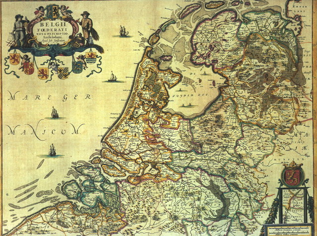
Map of the Republic of the Seven United Netherlands
Drawn by Joannes (or Johannes) Janssonius
Part of his collection Belgii Foederati Nova Descriptio
Published in Amsterdam in 1658
Map predates international copyright law, plus author has sadly deceased some 317 years ago.
| Creator/Artist | ||
|---|---|---|
| Name |
Janssonius, Jan
|
|
| Alternative names |
Jan Jansson, Jan Jansz, Jan Janszoon, Joannes Janssonius
|
|
| Date of birth/death | 1588 | 1664 |
| Location of birth/death | Arnhem | Amsterdam |
| Work period | 1616-1664 | |
| Work location |
Amsterdam
|
|
 |
This image (or other media file) is in the public domain because its copyright has expired. This applies to the United States, Canada, the European Union and those countries with a copyright term of life of the author plus 70 years. العربية | Asturianu | Български | Català | Česky | Dansk | Deutsch | English | Ελληνικά | Esperanto | Español | Euskara | فارسی | Français | Gaeilge | Galego | עברית | हिन्दी | Bahasa Indonesia | Italiano | 日本語 | 한국어 | Kurdî / كوردی | Lietuvių | Magyar | Nederlands | Norsk (nynorsk) | Македонски | Bahasa Melayu | Polski | Português | Română | Русский | Slovenčina | Slovenščina | Shqip | Suomi | Sámegiella | Türkçe | 中文(简体) | 中文(繁體) | 粵語 | +/- |
File history
Click on a date/time to view the file as it appeared at that time.
| Date/Time | Dimensions | User | Comment | |
|---|---|---|---|---|
| current | 11:46, 30 July 2005 | 3,426×2,550 (1.22 MB) | BenTels | (Map of the Republic of the Seven United Netherlands<br> Drawn by Joannes (or ''Johannes'') Janssonius<br> Part of his atlas ''Belgii Foederati Nova Descriptio''<br> Published in Amsterdam in 1658 Map predates international copyright law, plus author ) |
File links
The following file is a duplicate of this file: