Image:Byzantiumby650AD.JPG
From Wikipedia, the free encyclopedia

Size of this preview: 640 × 296 pixels
Full resolution (800 × 370 pixels, file size: 47 KB, MIME type: image/jpeg)
Summary
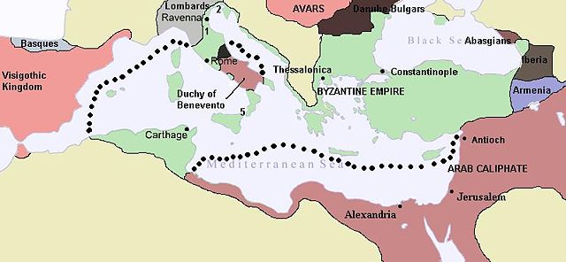
Map of the Byzantine Empire in 650 A.D.. It still controlled much of the Balkans, Asia Minor, The Exarchate of Ravenna (Italy), Exarchate of Carthage (North Africa), Rome, Naples, and the major Mediterranean islands. Egypt, Libya, Syria and Palestine had recently been lost to Arabs conquest.
Licensing
|
File history
Click on a date/time to view the file as it appeared at that time.
| Date/Time | Dimensions | User | Comment | |
|---|---|---|---|---|
| current | 00:49, 7 November 2007 | 800×370 (47 KB) | Justinian43 ( Talk | contribs) | (Map of the Byzantine Empire by 650 A.D., by this year it controlled much of the Balkans, Asia Minor, The Exarchate of Ravenna, Exarchate of Carthage, Rome, Naples, and the major Mediterranean Islands.) |
See the setup instructions for more information.
File links
The following file is a duplicate of this file:
The following pages on Schools Wikipedia link to this image (list may be incomplete):
Categories: GFDL images | Cc-by-sa-3.0,2.5,2.0,1.0 images | Self-published work
